Are you ready for an adventure that’s as big as Texas itself? Nestled in the rugged beauty of the Chihuahuan Desert, Big Bend National Park is a treasure trove of natural wonders and a testament to the Lone Star State’s wild heart. Spanning over 800,000 acres, this massive park offers everything from limestone canyons carved by the Rio Grande to the high-altitude forests of the Chisos Mountains.
It is a place where the silence is profound, the stars are brilliant, and the horizon seems to stretch on forever. The park's vastness is its defining characteristic, offering a sense of scale that is increasingly rare in the modern world.
A Big Bend trip in 2026 demands careful preparation: this park sits hundreds of miles from any major city, with virtually no cell service, extreme desert heat, and one major infrastructure project that changes everything planned around the Chisos Mountains. From the towering walls of Santa Elena Canyon to the natural hot springs on the Rio Grande, Big Bend rewards those who arrive ready with the right knowledge.
This guide covers the 2026 Chisos Basin closure, entrance fees, the top hiking trails, camping options, stargazing, river kayaking, birdwatching, pet rules, campfire restrictions, and gateway town logistics — everything needed for a successful West Texas adventure.
Before you pack your bags, it is essential to understand the "three parks in one" layout of Big Bend: the mountain, the desert, and the river. Each region offers a distinct climate and ecosystem, making Big Bend one of the most biologically diverse national parks in the United States.
You can experience a 20-degree temperature drop just by driving from the desert floor into the Chisos Basin. This diversity is why the park is also designated as a UNESCO International Biosphere Reserve. For more incredible destinations across the Lone Star State, check out our guide to the best places to visit in Texas.
Big Bend National Park: Quick Facts & 2026 Visitor Info
Planning a trip to the remote corners of West Texas requires attention to detail. The Big Bend National Park is located hundreds of miles from the nearest major city, and services are limited once you enter the gates. Below are the essential facts you need for a successful 2026 visit. We recommend checking the official NPS website for daily alerts, as conditions in the desert can change rapidly.
Detail | 2026 Information |
|---|---|
Location | Brewster County, West Texas (Near Terlingua/Study Butte) |
Entry Fee | $30 per private vehicle (Valid for 7 days) |
Payment Method | Cashless Only (Credit/Debit/Digital) |
Operating Hours | Park gates open 24/7; Visitor centers vary (typically 8:30 AM – 5:00 PM) |
Main Visitor Center | Panther Junction (Open daily) |
Best Time to Visit | October through April (Peak season) |
Chisos Basin Status | Closing May 1, 2026 for major multi-year renovation |
Cell Service | Extremely limited; expect no signal in most areas |
Gas Stations | Panther Junction and Rio Grande Village only |
Entrance Fees and 2026 Operating Hours
As of 2026, Big Bend National Park has transitioned to a fully cashless system. You should be prepared to pay your entrance fees using a credit card, debit card, or digital payment method at the entrance stations or visitor centers.
The standard entrance fee is $30 per private vehicle, which covers all occupants for seven consecutive days. If you are visiting on a motorcycle, the fee is $25, while individuals entering by foot or bicycle pay $15. Youth aged 15 and under are admitted free of charge. If you plan to visit multiple national parks within a year, we highly recommend the America the Beautiful Pass for $80.
While the park itself remains open 24 hours a day, 365 days a year, the visitor centers operate on set schedules. The Panther Junction Visitor Center is the park's headquarters and is open from 8:30 AM to 5:00 PM daily.
This is the best place to obtain backcountry permits, speak with rangers, and purchase maps. Other seasonal centers, such as Persimmon Gap and Rio Grande Village, typically operate from November through April. For those planning multiple park trips this year, we recommend looking into the top 10 best state parks in Texas to complement your national park adventure.
The 2026 Chisos Basin Closure: A Major Infrastructure Project
The biggest news for travelers in 2026 is the scheduled multi-year closure of the Chisos Basin. Starting May 1, 2026, a $22 million infrastructure project funded by the Great American Outdoors Act will begin. This massive renovation will lead to the temporary closure of the Chisos Mountains Lodge, the Chisos Basin Campground, and all associated visitor services in the area.
This project is designed to replace aging water lines, upgrade electrical systems, and modernize the lodge's facilities for future generations of visitors. This is a critical update for any 2026 travel guide planning.
Access to the Chisos Basin Road will be restricted to construction traffic only to ensure public safety during these intense renovations. This means that iconic trails like the Lost Mine Trail and The Window Trail will be completely inaccessible from the Basin trailhead for the duration of the project.
If you are visiting after May 1, 2026, you will need to focus your itinerary on the desert and river regions of the park. We suggest planning your mountain hikes for early 2026 if you wish to see the Chisos Basin before it closes. For an alternative mountain experience, consider exploring the Davis Mountains State Park, which remains fully open.
The Geological History of Big Bend: Volcanic Peaks & Ancient Seas
The landscape of Big Bend National Park is a textbook of geological history, written over millions of years. This region was once covered by a shallow sea, evidenced by the vast limestone layers that form the walls of Santa Elena and Boquillas Canyons. These limestone beds are rich in fossils, including ancient sea creatures and dinosaurs.
The park is one of the best places in the world to study the transition between the Cretaceous and Tertiary periods. Visitors can see the impact of these ancient environments in the colorful layers of the desert floor.
The Chisos Mountains themselves are the result of intense volcanic activity that occurred roughly 30 to 40 million years ago. Massive eruptions deposited layers of ash and lava, which were then uplifted and eroded into the jagged peaks we see today. Features like the "Window" and Emory Peak are volcanic remnants that have survived millions of years of wind and water erosion.
Understanding this volcanic history adds a layer of appreciation to every hike. The park's geology isn't just about the past; the Rio Grande continues to carve the landscape every single day, deepening its canyons and moving tons of sediment toward the Gulf of Mexico.
Understanding the Three Regions of Big Bend
Big Bend National Park is often described as "three parks in one" because of its drastically different ecosystems. Understanding these regions will help you plan your daily activities and prepare for the varying weather conditions. Each region requires a different approach to safety and exploration.
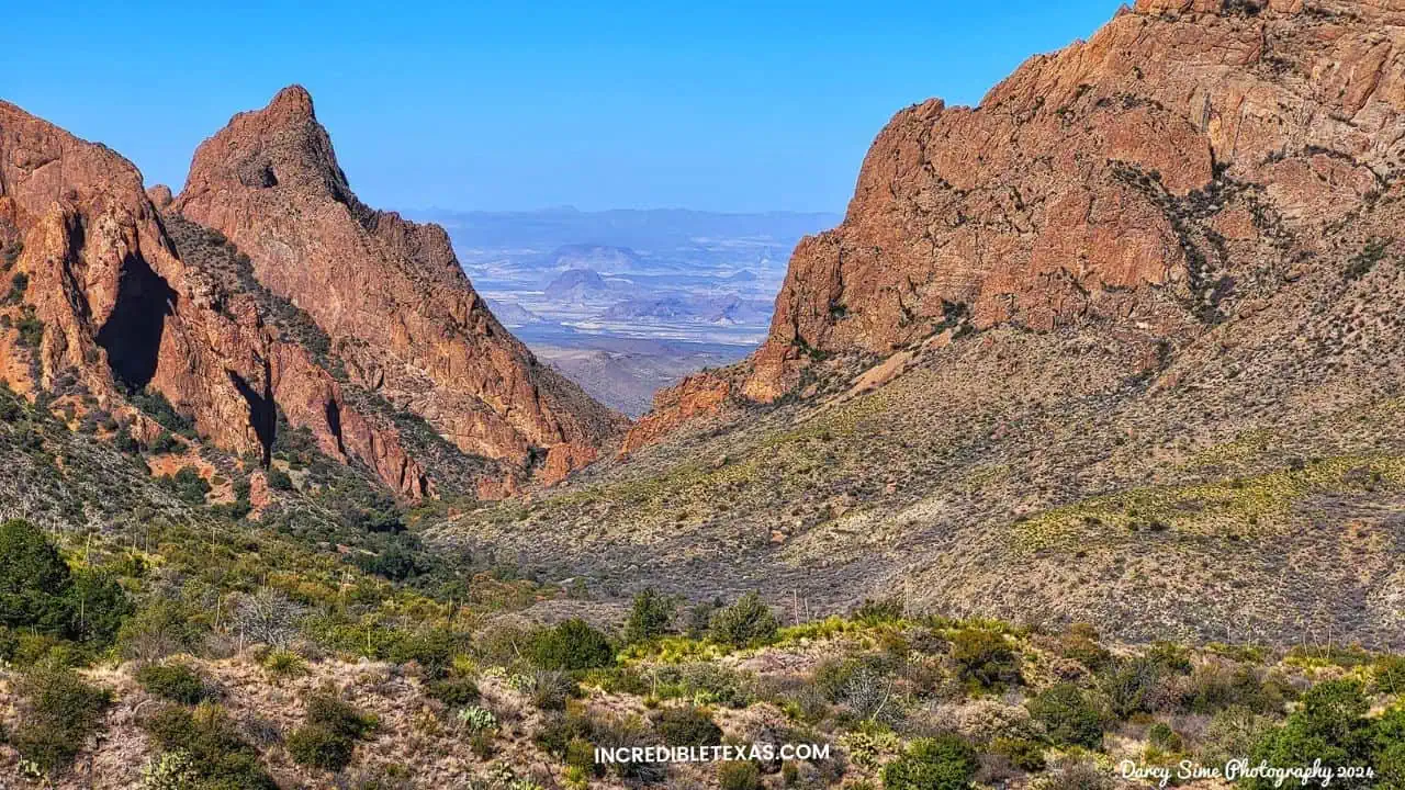
1. The Chisos Mountains
Rising like a green island out of the desert, the Chisos Mountains are the only mountain range in the United States contained entirely within a single national park. Here, the temperatures are significantly cooler, and the landscape is dominated by pinyon pine, juniper, and oak trees.
This region is the heart of the park's mountain hiking system and is home to Emory Peak, the highest point in the park. Because of the cooler climate, the Chisos Mountains are a popular refuge during the scorching summer months. You might even find yourself reaching for a jacket in the evening, even when the desert below is sweltering.
2. The Chihuahuan Desert
The vast majority of the park consists of the Chihuahuan Desert. This is a land of stark beauty, characterized by unique geological formations, volcanic remains, and resilient desert flora. The desert region is where you will find the Ross Maxwell Scenic Drive and the famous Balanced Rock.
While it may look barren at first glance, the desert is teeming with life, from lizards and roadrunners to blooming cacti and agave. Winter is the ideal time to explore this region, as summer temperatures can easily exceed 110°F. The desert's silence is its own form of music, broken only by the wind and the occasional call of a cactus wren.
3. The Rio Grande Corridor
The Rio Grande forms the southern boundary of the park, creating a lush ribbon of green that contrasts sharply with the surrounding desert. This river corridor features massive limestone canyons, such as Santa Elena and Boquillas, and provides essential water for the park's wildlife.
Visitors can enjoy canoeing, kayaking, or simply walking along the river's edge. The Hot Springs area is also located within this region, offering a chance to soak in natural mineral waters while looking across the river into Mexico. The river is the lifeblood of the park, a constant presence in an otherwise arid land.
Big Bend National Park vs. Big Bend Ranch State Park
Many visitors confuse Big Bend National Park with its neighbor, Big Bend Ranch State Park (BBRSP). While they share a name and a border, they offer very different experiences. Big Bend National Park is more developed, with paved roads leading to the most iconic sights.
It is the best choice for first-time visitors who want to see the "hits" like Santa Elena Canyon and the Chisos Basin. The national park also offers more visitor services and educational programs led by NPS rangers. It is designed for high-volume tourism while still preserving the wilderness experience.
In contrast, Big Bend Ranch State Park is often called "the other side of nowhere." It is significantly more rugged and remote, with few paved roads and limited services. It is a haven for mountain bikers and experienced backcountry hikers who want to avoid the crowds.
If the Chisos Basin is closed during your 2026 visit, Big Bend Ranch State Park provides an excellent alternative for rugged mountain adventures. The state park's FM 170 drive, known as "The River Road," is often cited as the most scenic drive in Texas. For more details on the state park, see our guide to the best things to do in Big Bend Ranch State Park.
Top 10 Hiking Trails in Big Bend National Park
Hiking is the primary way to experience the diverse landscapes of Big Bend National Park. From shaded mountain canyons to sun-baked desert flats, there is a trail for every skill level. According to the Official NPS Hiking Guide, the park features over 150 miles of trails. Below we highlight our top ten picks, categorized by region and including the latest 2026 accessibility updates.
Detailed Look at the Top 5 Hikes at Big Bend National Park
- Lost Mine Trail (Mountains): This 4.8-mile moderate hike is often called the "jewel" of the park. It offers steady climbs through juniper and pine forests, culminating in a ridge with panoramic views of Casa Grande and Juniper Canyon. It is the perfect "effort-to-reward" hike for those with limited time. The trail provides an excellent introduction to the park's mountain ecosystem. Note: This trail will be inaccessible after May 1, 2026.
- Santa Elena Canyon Trail (River): This easy 1.7-mile trail is a must-do for every visitor. It takes you into the mouth of a massive limestone canyon where 1,500-foot vertical walls dwarf the Rio Grande below. The trail involves a short climb via switchbacks and then follows the riverbank into the heart of the canyon. It is particularly stunning in the late afternoon when the sun lights up the canyon walls.
- South Rim Loop (Mountains): For the experienced hiker, the South Rim is widely considered the best hike in Texas. This strenuous 12-14 mile trek offers breathtaking views from a 2,000-foot escarpment. On a clear day, you can see deep into the mountains of Mexico. It is a full-day commitment but well worth the effort for the solitude and scenery. Note: Trailhead closes May 1, 2026.
- Emory Peak (Mountains): As the highest point in the park (7,825 ft), Emory Peak offers 360-degree views of the entire Big Bend region. The 10.5-mile round trip is strenuous, and the final 50 feet require a technical rock scramble. It is not for those with a fear of heights, but the view from the top is unparalleled. You can often see the curvature of the earth from this vantage point. Note: Trailhead closes May 1, 2026.
- Balanced Rock / Grapevine Hills (Desert): This easy-to-moderate 2.2-mile trail leads you through a desert wash to a stunning boulder field. The highlight is "Balanced Rock," a natural window-like formation that perfectly frames the desert landscape. It is a great spot for photography, especially during the golden hour when the rocks glow orange.
Other Notable Trails for 2026
- The Window Trail: A 5.6-mile moderate hike that descends from the Chisos Basin toward a narrow V-shaped notch in the mountain wall. It ends at a smooth rock pour-off with a dramatic view of the desert floor thousands of feet below.
- Hot Springs Historic Trail: An easy 1-mile walk that passes Native American pictographs and historic homestead ruins. It ends at 105°F natural hot springs right on the edge of the Rio Grande. It is one of the most relaxing spots in the park.
- Boquillas Canyon Trail: A 1.4-mile easy hike that offers views of towering limestone walls and the quiet village of Boquillas across the river. You can often hear the "singing Mexicans" across the water, a unique cultural experience in the park.
- Mule Ears Spring Trail: A 3.8-mile moderate desert hike that leads toward two massive twin rock towers resembling mule ears. The trail ends at a lush desert spring, a hidden oasis in the middle of the arid landscape.
- Ernst Tinaja: An easy 1.6-mile hike through colorful limestone layers to deep natural water holes. This trail is located off the unpaved Old Ore Road and requires a high-clearance vehicle to reach the trailhead. It is a geologist's dream.
Big Bend National Park Alternative Itineraries: Visiting During the Closure
If your visit falls after May 1, 2026, you will need to pivot your plans toward the desert and river. A perfect three-day "Lower Big Bend" itinerary focuses on the Ross Maxwell Scenic Drive and Rio Grande Village. On your first day, explore Santa Elena Canyon in the morning to beat the heat, followed by a visit to the Mule Ears viewpoint.
This allows you to experience the Big Bend National Park's dramatic geology without needing access to the high-mountain trails of the Chisos Basin. Finish your day by watching the sunset from Sotol Vista.
On your second day, head to the Rio Grande Village area. Hike the Boquillas Canyon Trail and then relax in the natural hot springs along the river. If you have a passport, consider crossing into Mexico at the Boquillas Port of Entry for a traditional lunch.
Your final day can be spent exploring the remote desert landscapes of the Grapevine Hills or hiking the Chimneys Trail. This itinerary captures the essence of the park's "Border-Tech" updates and ensures a fulfilling experience even while the Basin is closed. You will find that the desert has a unique beauty all its own.
Big Bend National Park Camping and Lodging: Planning Your 2026 Stay
Camping in Big Bend National Park is an unforgettable experience, especially under some of the darkest night skies in the lower 48 states. The park is a certified International Dark Sky Park, meaning the stargazing is world-class.
However, with the Chisos Basin campground closing in May 2026, competition for sites at Rio Grande Village and Cottonwood will be higher than ever. You must book your reservations via Recreation.gov exactly six months in advance to secure a spot. Most sites sell out within minutes of being released at 8:00 AM MST.
Campground | Region | 2026 Status | Amenities |
|---|---|---|---|
Rio Grande Village | River | Open Year-Round | Water, Flush Toilets, Dump Station, Camp Store |
Chisos Basin | Mountains | Closing May 1 | Water (Limited), Flush Toilets (Closing soon) |
Cottonwood | River | Seasonal | Pit Toilets, Water (No Generators Allowed) |
Backcountry | Various | Permit Required | Primitive (No Facilities, Carry-in/Carry-out) |
If you prefer a more developed experience, the Rio Grande Village RV Park (operated by a concessionaire) offers full hookups for larger rigs. This is the only place in the park with full utility connections. For those looking for alternative mountain adventures while the Basin is closed, consider visiting Palo Duro Canyon State Park, which offers similar dramatic canyon scenery. Additionally, if you are looking for a state park closer to the Hill Country, Guadalupe River State Park provides excellent river access and camping. For those who prefer hotel-style lodging, searching for "ghost town lodging Terlingua" will reveal unique boutique options just outside the park gates. The Lajitas Golf Resort is another luxury option located between the national and state parks.
The Stargazing Experience at Big Bend National Park: International Dark Sky Park
Big Bend National Park is one of the premier locations for stargazing in the world. It is a certified International Dark Sky Park and is part of the largest Dark Sky Reserve in the world. On the Bortle Scale, which measures light pollution, much of Big Bend sits at a Level 1—the darkest possible rating.
This means that the Milky Way is often so bright it can cast a faint shadow on the ground. For city dwellers, the sheer number of visible stars is often overwhelming and profound. You can see the Andromeda Galaxy with the naked eye on a clear, moonless night.
To get the best stargazing experience, we recommend finding a spot away from the major campgrounds. Sotol Vista and the Mule Ears viewpoint are excellent locations for photography and deep-sky observation.
In 2026, the park will continue its "Night Sky" ranger programs, which offer educational talks and telescope viewing. Remember to use only red-light flashlights to preserve your night vision and the natural darkness of the desert. This experience is a top draw for traffic interested in the "Dark Sky Reserve" status. The park's commitment to dark skies involves special lighting fixtures that minimize upward light spill.
Best Scenic Drives in Big Bend National Park
If you have limited time or prefer to see the Big Bend National Park from your vehicle, Big Bend offers some of the most beautiful scenic drives in the United States. These routes allow you to see the park's major landmarks without committing to long hikes. Driving in Big Bend is a journey through time, with every mile revealing a different chapter of the earth's history.
Ross Maxwell Scenic Drive
This 30-mile paved route is the premier scenic drive in the park. It showcases the park’s geological history, from ancient volcanic eruptions to the carving of the Rio Grande. Key stops along the drive include Sotol Vista, which offers a panoramic view of the entire western side of the park, and the Mule Ears Viewpoint.
The drive ends at the magnificent Santa Elena Canyon. We recommend starting this drive early in the morning to avoid the heat and to see the canyon walls in the best light. This is the heart of any 2026 travel guide itinerary. Don't miss the Tuff Canyon stop, where you can walk into a gorge carved from volcanic ash.
The River Road (4WD Required)
For adventure seekers with high-clearance 4WD vehicles, the 51-mile River Road offers a true backcountry experience. This unpaved route connects the Rio Grande Village area to the Castolon area and passes through some of the most isolated sections of the park. It can take a full day to navigate and requires self-sufficiency, as there are no services or cell signal.
Always check the latest road conditions at a ranger station before heading out, as desert rains can quickly wash out these primitive tracks. This is the ultimate "4WD primitive roads Big Bend National Park guide" route. You should carry at least two spare tires and extra fuel for this journey.
Old Ore Road (4WD Required)
This 26-mile rugged road was originally used in the early 1900s to transport ore from Mexican mines. Today, it provides access to the Ernst Tinaja trailhead and offers excellent views of the Chisos Mountains from the east. Like the River Road, this is for experienced drivers only and requires a high-clearance vehicle. It is one of the best ways to experience the raw, untouched beauty of the Chihuahuan Desert. The road passes through areas of striking geological diversity, with limestone hills and volcanic peaks surrounding you at every turn.
A Brief History of Big Bend: From Pioneers to Parks
The history of Big Bend is as layered as its limestone cliffs. For thousands of years, Native Americans, including the Chisos, Mescalero Apache, and Comanche, moved through this region, following the seasons and the water.
You can still see evidence of their presence today in the form of pictographs and mortar holes used for grinding seeds. This cultural heritage is part of why the park is designated as an International Biosphere Reserve. These early inhabitants understood the desert's secrets, surviving in an environment that many modern visitors find daunting.
In the late 19th and early 20th centuries, the region saw an influx of Spanish and American explorers, miners, and ranchers. Mercury mining was a major industry in Terlingua, and large-scale cattle and sheep ranching operations were established throughout the park. However, the harsh desert environment made it difficult to sustain these industries long-term.
In 1944, thanks to the efforts of conservationists and the State of Texas, Big Bend National Park was officially established. Today, many of the old ranch houses and mining structures are preserved as historical sites, offering a glimpse into the park's rugged past. The Sam Nail Ranch and the Homer Wilson Ranch are excellent examples of these surviving structures.
Wildlife and Flora: Biodiversity in the Desert
Big Bend National Park is a haven for wildlife enthusiasts and birders. The park is home to over 450 species of birds, including the rare Colima Warbler, which nests only in the Chisos Mountains. As you explore, keep an eye out for javelinas (collared peccaries) near the campgrounds and roadrunners dashing across the desert flats. In the higher elevations, you might even spot a Mexican black bear or a mountain lion.
Remember to always keep a safe distance and never feed the wildlife, as these animals are protected within this International Biosphere Reserve. The park's diverse habitats support an incredible array of life, from the smallest insects to the largest predators.
The flora is equally impressive and highly adapted to the arid climate. The Chihuahuan Desert landscape is dotted with iconic plants like the spindly ocotillo, which bursts into red blooms after a rain, and the giant dagger yucca. In the spring, usually between February and April, the desert can come alive with Big Bend Bluebonnets.
These are significantly taller and hardier than their central Texas counterparts. This biodiversity is what makes Big Bend a globally recognized treasure. The park is also home to many species of cacti, including the rare Living Rock cactus, which blends in perfectly with the desert floor. For more wildflower routes, see our Hill Country bluebonnet trails guide.
Preparation: Your Big Bend National Park Packing List
Because of its remote location, you cannot simply "run to the store" if you forget something in Big Bend. Proper preparation is the key to a safe and enjoyable trip. Below is our essential packing list for a 2026 visit. We recommend double-checking your gear before you leave the last major towns of Alpine or Marathon.
Essential Gear
- Water: At least one gallon per person per day. Do not rely on park springs, which can be unreliable or contaminated.
- Sun Protection: High-SPF sunscreen, wide-brimmed hat, and UV-rated sunglasses are non-negotiable.
- Footwear: Sturdy hiking boots with good traction; desert rocks are often sharp and loose.
- Navigation: Physical maps and downloaded offline maps (Google Maps or AllTrails) are essential as there is no signal.
- First Aid Kit: Include tweezers (for cactus spines), plenty of electrolytes, and moleskin for blisters.
Vehicle Preparation
- Full Tank of Gas: Fill up in Alpine, Marathon, or Study Butte before entering the park gates.
- Spare Tire: Ensure your spare is inflated and you have a working jack. Rock punctures are common on unpaved roads.
- Extra Fluids: Carry extra coolant and oil for your vehicle, especially if driving the 4WD roads.
Exploring Gateway Communities: Terlingua, Marathon, and Alpine
While the national park is the main attraction, the surrounding gateway communities offer their own unique charm. Terlingua Ghost Town, located just outside the western entrance, is a must-visit. This former mining town is now a vibrant community of artists, musicians, and desert dwellers.
Be sure to grab a drink at the Starlight Theatre and watch the sunset from the famous porch. Finding "ghost town lodging Terlingua" is a great way to base yourself for a multi-day trip. The town comes alive at night with live music and local storytelling.
To the north, the town of Marathon serves as the eastern gateway to the park. It is home to the historic Gage Hotel, a beautifully restored 1927 property that offers a touch of luxury in the desert. Marathon is also an excellent spot for stargazing and is known for its quiet, slow-paced atmosphere. The "Marathon TX to Big Bend drive time" is roughly 45 minutes to the Persimmon Gap entrance. It is a peaceful alternative to the busier Terlingua side of the park.
Alpine is the largest nearby city and serves as a major hub for supplies and regional culture. It is home to Sul Ross State University and the Museum of the Big Bend, which features excellent exhibits on the region's natural and human history. Alpine offers a wider range of dining and lodging options than the smaller gateway towns. It is an essential stop for anyone traveler looking to experience the full culture of the Big Bend region. If you are traveling through the state, checking regional Texas guides can help you plan a well-rounded itinerary.
Essential Tips for a Safe Visit to Big Bend National Park
Safety is paramount in such a remote and extreme environment. The desert heat can be unforgiving, with temperatures frequently exceeding 100°F during the summer months. You should carry at least one gallon of water per person per day and avoid strenuous activity during the midday heat.
Additionally, cell service is virtually non-existent in most parts of the park, so downloading offline maps is a must. If you encounter a mountain lion or bear, stay calm, make yourself look large, and back away slowly; never run. Always store food in bear-proof containers or your vehicle's trunk.
In 2026, visitors may also notice "Smart Wall" technology near certain border areas. This technological surveillance is part of modern border management but does not impact standard park activities or access. It is designed to be less intrusive than physical barriers while maintaining security.
If you plan to cross the Rio Grande into the village of Boquillas, Mexico, remember that a valid passport is required for re-entry into the United States. The crossing is typically open from Friday through Monday during the summer and Wednesday through Sunday during the winter. For those exploring other river regions in Texas, Texas has many excellent river parks that complement a Big Bend trip.
Big Bend National Park Weather: Month-by-Month Guide
Big Bend's position in the Chihuahuan Desert means weather defines your experience as much as any trail or canyon. The Chisos Mountains run 10–15°F cooler than the desert floor, so conditions vary dramatically depending on where you are in the park. Check the National Park Service Big Bend weather page for real-time updates before departure.
Month | Desert High (°F) | Desert Low (°F) | Chisos High (°F) | Conditions |
|---|---|---|---|---|
January | 56–64 | 30–38 | 45–54 | Cold nights; possible snow in Chisos; mild sunny days |
February | 62–70 | 34–42 | 50–60 | Excellent conditions; early wildflowers possible |
March | 70–80 | 40–50 | 58–68 | ⭐ Peak season begins; Big Bend Bluebonnets bloom |
April | 78–88 | 48–58 | 65–75 | ⭐ Best month overall; warm, dry, vibrant landscape |
May | 88–98 | 58–68 | 74–84 | Getting hot; schedule hikes before 9 AM |
June | 96–106 | 66–74 | 82–90 | 🔥 Extreme heat; desert hikes dangerous midday |
July | 96–104 | 66–74 | 80–88 | Monsoon season begins; afternoon flash flood risk |
August | 94–102 | 64–72 | 78–86 | Daily thunderstorms; humidity increases slightly |
September | 88–96 | 58–66 | 74–82 | Rains taper; dramatic skies; strong for river trips |
October | 78–86 | 48–58 | 64–74 | ⭐ Second peak season; comfortable; fewer crowds |
November | 66–74 | 38–48 | 54–64 | Excellent; crisp mornings; best stargazing clarity |
December | 56–66 | 30–40 | 44–54 | Quiet; cold nights; stunning winter desert clarity |
The rainy monsoon season runs from July through September, bringing afternoon thunderstorms that provide brief relief but create serious flash flood risks in desert washes and narrow canyons. Never camp or shelter in a dry wash during monsoon season. In summer, plan all outdoor activities before 10 AM and after 5 PM, when desert floor temperatures regularly exceed 100°F and dehydration risk peaks.
Pets at Big Bend National Park: Rules and Restrictions
Big Bend National Park allows pets in limited areas, but the restrictions are strict and designed to protect both the park's wildlife and your animal. Knowing these rules before you arrive prevents surprises at the trailhead, especially given that no kennel services exist anywhere inside the park.
- Allowed areas: Roads, paved surfaces, developed campgrounds, and primitive roadside campsites. Pets may accompany you on scenic drives and inside your vehicle.
- Prohibited areas: All hiking trails, off-road terrain, the backcountry, and the Rio Grande river itself. This restriction applies even if you carry the animal.
- Hot Springs: Pets are strictly prohibited at the Big Bend Hot Springs area, which is a day-use only zone.
- Leash requirement: All pets must remain on a leash no longer than 6 feet at all times within the park — in campgrounds, at trailheads, and at overlooks.
- Unattended pets: Leaving a pet unattended in a vehicle in extreme desert heat is dangerous and is not permitted if it creates a risk to the animal.
- No kennels available: There are no pet boarding or kennel services inside the park. If your group plans to hike, someone must remain at camp with the pet.
- Service animals: Qualified service animals are permitted throughout all areas of the park and in all park facilities, provided they remain leashed.
Rio Grande River Activities: Kayaking, Rafting, and Hot Springs
The Rio Grande defines Big Bend's southern boundary, carving three major limestone canyons that rank among the most spectacular river paddling destinations in North America. With over 118 miles of river accessible within park boundaries, options range from beginner-friendly flat-water canoe trips to technical whitewater runs through narrow slot canyons. River trips reveal sections of the park completely inaccessible by foot or vehicle.
The Three Main Paddling Canyons
Canyon | Length | Difficulty | Best For |
|---|---|---|---|
Santa Elena Canyon | ~17 miles | Class I–III | Most scenic; 1,500-ft walls; some technical rapids |
Mariscal Canyon | ~10 miles | Class II–III | Remote; requires high-clearance vehicle to reach put-in |
Boquillas Canyon | ~33 miles | Class I | Gentle; longest canyon; excellent birding; views into Mexico |
Overnight river trips require a backcountry permit obtained at Panther Junction Visitor Center. Day trips do not require a permit. Commercial outfitters in Terlingua — including Far Flung Outdoor Center and Big Bend River Tours — offer guided half-day and multi-day expeditions with all equipment included. Always check current NPS river conditions before launching, as monsoon rains can cause rapid water level changes and debris hazards.
The Big Bend Hot Springs
The Big Bend Hot Springs, located near Rio Grande Village, reach 105°F and sit directly on the bank of the Rio Grande. Access is via a 1-mile easy trail from the Hot Springs trailhead. This is a day-use only area — no overnight camping, no pets, and no alcoholic beverages are permitted. Water shoes are strongly recommended for both the trail and the soaking area, as the rocky surfaces can be slippery. The Mexican village of Boquillas del Carmen is visible across the river from the springs.
Birdwatching at Big Bend National Park: 450+ Species Guide
Big Bend National Park hosts more bird species than any other national park in the United States, with over 450 documented species within park boundaries. The park's position at the convergence of desert, mountain, and river ecosystems creates habitat for a remarkable array of resident breeding birds and migratory species. Spring migration from mid-April through late May brings peak diversity, though the park rewards birders in every season.
Signature Species You Can Only Find Here
- Colima Warbler: Big Bend is the only place in the United States where this species nests. Found exclusively in the Chisos Mountains above 6,000 feet — Boot Canyon and the South Rim trail are the most reliable locations. Active from late April through July.
- Lucifer Hummingbird: A desert specialty found near agave-rich washes and hillsides below 5,000 feet. The Chisos Basin foothills and Paint Gap area are consistent sighting spots from May through August.
- Varied Bunting: A gem-colored desert bird found along brushy canyon edges. Males are strikingly purple-red with a blue head. Active from May through August throughout the lower Chisos foothills.
- Elf Owl: The world's smallest owl, nesting in saguaro cacti and desert scrub. Listen for its sharp, rapid call at dusk near campground areas.
- Black-capped Vireo: A federally protected species that nests in scrub oak thickets within the Chisos foothills. Best detected by voice in April and May.
Best Birdwatching Locations
- Rio Grande Village: The single best birding hotspot in the park. The cottonwood grove and nature trail attract warblers, tanagers, vireos, and flycatchers in extraordinary numbers during spring migration. The 0.5-mile nature trail loop through dense riparian vegetation is accessible year-round.
- Boot Spring (Chisos Mountains): A high-elevation spring inside the Chisos Basin that reliably produces Colima Warblers, Painted Redstarts, and Mexican Jays. Requires a 4.5-mile hike from the Basin trailhead — note this area closes May 1, 2026.
- Cottonwood Campground: River-edge cottonwood trees make this an excellent migration stopover point in April–May and September–October.
- Hot Springs area: The riparian edge here attracts species that don't regularly appear elsewhere in the park, including Tropical Kingbird and various shorebirds during seasonal creek flow.
Campfire Rules and Fire Restrictions at Big Bend National Park
Big Bend National Park enforces some of the strictest fire regulations of any national park in the country, reflecting the extreme fire danger of the Chihuahuan Desert ecosystem. These rules apply everywhere within park boundaries at all times — there are no exceptions based on location or weather conditions.
- Ground fires: Completely and permanently prohibited throughout the entire park. This includes beach fires along the Rio Grande and campsite fires on any surface.
- Wood fires: Prohibited throughout the park. Never collect or burn wood of any kind, including deadfall or driftwood.
- Charcoal: Allowed only in the above-ground grills provided at developed campgrounds (Chisos Basin, Rio Grande Village, and Cottonwood). All cold ash and charcoal must be packed out completely — leaving any residue is a violation.
- Liquid-fuel stoves: Permitted everywhere in the park, including the backcountry. This is the recommended cooking method for all visitors.
- River trips: Fires are permitted on multi-day river expeditions, but only using a fire pan that fully contains all ash and embers. Pack out all fire debris.
- Elevated restrictions: During periods of extreme drought or elevated fire danger, the park may impose temporary bans on even charcoal use. Always verify current fire conditions at Panther Junction Visitor Center before your trip.
The 2026 water infrastructure failure in the Chisos Basin has heightened fire risks in that area. Given the extremely limited emergency response capacity in this remote environment — the nearest fire services are many hours away — all visitors must treat fire prevention as a non-negotiable safety responsibility, not a guideline.
Big Bend National Park 2026 Expert FAQ
Is the Chisos Basin closed in 2026?
Yes, starting May 1, 2026, the Chisos Basin area will be closed for a major multi-year renovation project. This includes the lodge, campground, restaurant, and all mountain trailheads accessed from the Basin road. Plan your mountain hikes for the early part of the year.
Is there a water shortage in Big Bend in 2026?
Early 2026 has seen critical water infrastructure failures in the Chisos Basin area. Visitors are advised to bring their own drinking water and be prepared for restricted services, including closed public restrooms replaced by portable toilets in certain areas. Conservation is essential for all visitors.
Can I legally cross into Mexico from Big Bend?
Yes, you can cross into Boquillas del Carmen via the Boquillas Port of Entry. A valid passport is required for all travelers, regardless of age. The crossing is seasonal, typically open from Friday to Monday in the summer and Wednesday to Sunday in the winter. It is a wonderful way to experience Mexican culture.
Is Big Bend safe for solo travelers in 2026?
Big Bend is generally very safe for solo travelers. However, due to the extreme heat and lack of cell service, you must inform someone of your itinerary and carry a satellite communicator if exploring remote backcountry areas. Staying on marked trails is the best way to ensure your safety. The park's remote nature means that help can be many hours away.
How many days do you need in Big Bend?
Because of the park's massive size and remote location, we recommend a minimum of three to four days to see the major highlights. This allows one day for the Chisos Mountains (if open), one day for the Ross Maxwell Scenic Drive and Santa Elena Canyon, and one day for the Rio Grande Village area. A week is ideal if you want to explore the backcountry or visit the nearby state park.
Is there cell service in Big Bend?
Cellular service is extremely spotty and unreliable. You can occasionally find service at the Panther Junction Visitor Center and certain high points in the Chisos Basin, but you should not rely on it for navigation. Satellite communicators are recommended for backcountry travel and are a standard part of a safe desert kit.
What is Big Bend National Park famous for?
Big Bend National Park is famous for three things above all: its remote and dramatic Chihuahuan Desert landscape, its designation as an International Dark Sky Park with some of the darkest skies in the United States (Bortle Scale Level 1 in most areas), and the Rio Grande's extraordinary limestone canyons — particularly Santa Elena Canyon with its 1,500-foot vertical walls. The park also holds the distinction of hosting more bird species than any other national park in the country, with 450+ documented species.
Are pets allowed at Big Bend National Park?
Pets are allowed in limited areas at Big Bend National Park — on roads, in campgrounds, and in vehicles — but are strictly prohibited on all trails, in the backcountry, and at the hot springs. All pets must be on a leash no longer than 6 feet at all times. No kennel services exist within the park, so if your group plans to hike, someone must remain at camp with the animal. Service animals are always permitted throughout all park areas and facilities.
Are campfires allowed at Big Bend National Park?
Ground fires and wood fires are strictly prohibited throughout Big Bend National Park. Charcoal is permitted only in the above-ground grills provided at developed campgrounds, and all cold ash must be packed out completely. Liquid-fuel stoves are the recommended cooking method for all campers and backpackers. During periods of extreme fire danger, even charcoal use may be temporarily prohibited — always verify current restrictions at Panther Junction before setting up camp.
Do I need a permit to hike in Big Bend National Park?
Day hikes on any of Big Bend's 150+ miles of marked trails do not require a permit. Backcountry camping overnight — whether at primitive roadside sites or on backpacking routes in the Chisos — requires a backcountry permit obtained at Panther Junction Visitor Center. Starting May 1, 2026, Chisos-area backcountry permits are no longer available online and must be obtained in person, up to 24 hours in advance. Day-use backcountry exploration (without overnight camping) remains permit-free.
Are the hot springs open at Big Bend National Park?
Yes, the Big Bend Hot Springs are open for day use near Rio Grande Village. The natural springs reach 105°F and sit directly on the bank of the Rio Grande. Access is via an easy 1-mile trail from the trailhead. The hot springs are a day-use only area — no overnight camping, no alcoholic beverages, and no pets are permitted on site. Water shoes are strongly recommended for the rocky trail and the soaking area itself. The Mexican village of Boquillas del Carmen is visible across the river, adding a distinctive border landscape to the experience.
Final Thoughts on Visiting Big Bend National Park
Big Bend National Park remains one of the last truly wild places in Texas. While the 2026 closures in the Chisos Basin may change how you plan your itinerary, the park’s vast desert landscapes and stunning river canyons still offer an unparalleled adventure. By preparing for the heat, booking your campsites early, and respecting the park's natural beauty, you can ensure a safe and memorable journey into the Lone Star State’s wild heart
No comments yet