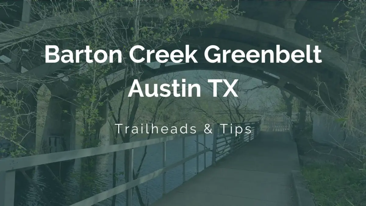
Barton Creek Greenbelt Austin TX Guide: Trailheads & Tips
Barton Creek Greenbelt Austin TX is Austin’s most flexible urban trail system: free trail access, more than 12 miles to explore, and enough trailheads that you can build a short creek walk or a longer hike around the day you actually have. If you have never been before, start at Zilker, go early, and treat footwear, parking, and water level as the real trip-planning variables.
The Zilker side sits minutes from downtown Austin by car, so the Greenbelt can fit into a half-day plan without turning into a full road trip. The park directory lists Barton Creek Greenbelt at 3753 S Capital of Texas Hwy., Austin, TX 78746, and the city Greenbelt page covers trailheads, hiking tips, and a map for the main corridor.
Check out: Emma Long Metropolitan Park Austin TX
The trail works best when you pick one entry point and one goal first. A quick hike, a swim-hole stop, or a bike ride can all work, but the day gets easier once you know which section of the creek you want and whether you are pairing it with another nearby Austin stop.
Open the city Greenbelt page before you leave so you can check the current trail map and access notes, then decide whether the Zilker trailhead, Spyglass, Gus Fruh, or the 360 side fits your plan best.
| Quick fact | Barton Creek Greenbelt Austin TX |
|---|---|
| Type | Urban creek corridor and trail system |
| Address | 3753 S Capital of Texas Hwy., Austin, TX 78746 |
| Length | Over 12 miles to explore |
| Main corridor | About 7.5 miles of trail |
| Cost | Trail access is free; some parking lots can charge a fee |
| Parking note | Zilker trailhead parking is free on weekdays and $7 on holidays and weekends from March through September |
| Pet rule | Dogs stay on leashes 6 feet or shorter |
| Hours / lighting | Limited to no lighting, and park facilities close after 10 p.m. |
| Best for | Hiking, biking, creek views, and swimming-hole stops |
What Barton Creek Greenbelt Is and Why It Matters
Barton Creek Greenbelt is not a single-gate park with one obvious front door. It is a creek corridor with trail segments, limestone edges, access points, and side paths that connect different Austin neighborhoods to the same green space.
The city describes more than 12 miles to explore, and the main trail corridor runs about 7.5 miles. That mix gives you real flexibility because you can visit for a short half-day and still leave with a complete outdoor experience.
The Barton Creek Greenbelt feels more alive than a paved city loop because the creek changes with rain, heat, and season. Water levels can shift quickly, rock can get slick, and the best route one week may feel different the next week.
For a first-time visit, keep the plan simple and start with Zilker or Spyglass. Those two trailheads make the Greenbelt easier to understand fast, and they keep you close to the part of Austin most people already know.
- Best if you want a short outing: Use one trailhead and stay near the creek.
- Best if you want a longer hike: Connect a central trailhead to another access point.
- Best if you want a city-to-nature break: Start near downtown and keep the rest of the day light.
- Best if you want a flexible Austin plan: Pair the trail with a nearby park or swimming stop.
The Austin Parks and Recreation locations page is useful when you want the park directory view rather than a trail-only overview, and it helps confirm how the Greenbelt fits into the city’s broader park network.
The Barton Creek Greenbelt is the kind of place where the access point shapes the whole outing. One trailhead can make the day feel like a creek walk, another can make it feel like a swim stop, and another can turn it into a longer point-to-point hike with a cleaner finish.
The best version of the Barton Creek Greenbelt usually matches your energy level instead of your ambition. If you only want a quick hour outside, stop early; if you want a fuller half-day, connect two trailheads and build in time for water, shade, and a slower return.
Barton Creek Greenbelt Main Access Points and Trailheads
Access matters more here than at a normal city park because the Barton Creek Greenbelt spreads across several entrances. If you choose the trailhead first, you can decide whether your day should feel like a creek walk, a swim-hole stop, a bike ride, or a longer point-to-point route.
For a first-time visit, Zilker is the easiest starting point, and Gus Fruh is one of the clearest water-focused access points. Spyglass, 360, Gaines, and Trail’s End each serve different parts of the corridor, so the “best” entry is the one that matches the part of the Greenbelt you want.
| Trailhead | Best for | Planning note |
|---|---|---|
| Zilker / Barton Creek Greenbelt Trailhead | Easy first visit and close-in access | Parking at 2212 William Barton Dr. is free on weekdays and $7 on holidays and weekends from March through September |
| Spyglass Trailhead | Central access to the middle sections | Useful when you want a shorter reach into the trail system |
| Barton Hills School Park Trailhead | Neighborhood access and a flexible start | Good for south-central trail plans |
| Gus Fruh Trailhead | Creek time and water-oriented visits | One of the better access points when the goal is a swim-hole stop |
| 360 Trailhead | West-side access and a longer trail feel | Works well when you want a more rugged outing |
| Gaines Trailhead | MoPac-side access and a different entry option | Helpful when traffic or parking makes other starts less convenient |
| Trail’s End / Camp Craft Trail access | Alternate south-side trail access | Useful when you want another route in or out |
Zilker / Barton Creek Greenbelt Trailhead
Zilker is the easiest place to start when you want the Greenbelt to feel simple on the first try. The city’s Violet Crown Trail project begins at the Barton Creek Greenbelt entrance at Zilker Park, so this trailhead also works well if you want a longer trail connection later in the day.
The parking detail matters here. The lot at 2212 William Barton Drive is free on weekdays, and it carries a $7 flat fee on holidays and weekends from March through September, so you can save time and money by choosing the right day or arriving early.
If you want to stretch the outing, Zilker Park is the cleanest add-on because you can move from trail time to lawns, events, or a picnic without leaving the same part of Austin.
Spyglass Trailhead
Spyglass is a strong choice when you want to reach the central part of the Barton Creek Greenbelt without starting from the most obvious entrance. That matters on busy weekends because a less flashy access point can keep the visit calmer from the beginning.
This trailhead works well for hikers who want a moderate outing and for people who only need a shorter walk before heading back into Austin. The Barton Creek Greenbelt changes character quickly, so a central access point can give you a good sense of the trail without committing to the full corridor.
If you are watching your time, Spyglass is the kind of access point that lets you build a compact plan without giving up the creekside feel.
Barton Hills School Park Trailhead
Barton Hills School Park Trailhead is useful when you want a south-central start that feels closer to the neighborhood scale than the big Zilker lot. It gives you another way into the system when the easiest-looking entrance is busier than you want.
This is a practical access point for a normal walk rather than a big production. You can use it to reach the creek, settle into a shorter loop, and still keep the day open for another Austin stop afterward.
Gus Fruh Trailhead
Gus Fruh is the trailhead many people think about first when the creek itself is the main goal. Water is the draw here, and the access point makes more sense when you want a swim-hole stop than when you want the easiest possible parking lot.
After recent rain, the section around Gus Fruh can feel more active and more scenic, but it also gets slick faster than a paved park path. If you want a swim-focused day, bring dry shoes, accept that conditions can change, and keep your expectations tied to the weather rather than a fixed beach-style setup.
For a more predictable swim plan, switch to Barton Springs Pool and leave the Greenbelt for a hike-first day.
360 Trailhead
The 360 Trailhead is the one to use when you want the west side of the Greenbelt and a more rugged feel underfoot. It pairs well with a longer route because the terrain and access pattern both feel less like a quick city stop and more like a real hike.
This access point also works well if you are already moving around west Austin and do not want to backtrack to the Zilker side. The Greenbelt is easier to enjoy when you match the start point to the part of the city you are already in.
Gaines Trailhead
Gaines gives you a useful MoPac-side entry when the standard starting points do not fit your route. That can save time if you are coming from another part of Austin and want a more direct jump into the trail system.
The value of Gaines is not flash, it is flexibility. A good trail plan often comes down to avoiding unnecessary driving, and Gaines can help you do that on a crowded day.
On a busy weekend, the access point matters even more than the distance on the map. If you want the least friction, choose a trailhead that sits closest to the part of Austin you are already visiting instead of forcing a perfect all-purpose start.
Trail’s End / Camp Craft Trail access
Trail’s End and Camp Craft Trail access are useful when you want a different way into the south side of the Greenbelt. They are the kind of trail connections that matter most when you are trying to plan a walk with a start and a finish that do not repeat the same pavement.
If your goal is to combine the Barton Creek Greenbelt with a neighborhood walk or a nearby lunch stop, this access style can be the simplest way to keep the day moving.
- Choose Zilker: when you want the easiest first visit and the cleanest city connection.
- Choose Spyglass: when you want a central access point with less of a “main entrance” feel.
- Choose Gus Fruh: when creek time matters more than a perfect parking lot.
- Choose 360: when you want west-side trail character and a more rugged outing.
- Choose Gaines or Trail’s End: when the best trip is the one that saves time on the drive.
Best Things To Do on the Barton Creek Greenbelt
The Greenbelt works because it can feel like three different Austin outings on the same day. You can hike the corridor, bike selected sections, or plan around one of the creek-side swimming spots when the water and weather are on your side.
If you want the most predictable water stop instead of the most adventurous one, use the Greenbelt for hiking and switch to Barton Springs Pool for the swim. The pool is the easier pick when you want consistency more than variation.
| Activity | Where it fits best | What helps |
|---|---|---|
| Hiking | The full corridor and any access point with a short connector | Traction shoes, water, and a simple route plan |
| Biking | Smoother stretches and early hours before foot traffic builds | A polite pace, a bell or voice callout, and extra caution near narrow crossings |
| Swimming-hole stops | Creekside sections with safe conditions after you check water level | Dry shoes, a towel, and a willingness to turn back if the water looks off |
| Photography | Morning light, shaded creek runs, and limestone walls after rain | A small bag, a charged phone, and patience at crowded overlooks |
Hiking is the simplest way to understand the place. The corridor gives you the creek, the trees, and the limestone at a human pace, and a short walk can still feel complete because the setting changes with every bend.
Biking makes sense when you are confident on shared trail space and willing to slow down near tighter sections. The Greenbelt is not a race course, and the people who enjoy it most on two wheels usually ride like guests in a shared outdoor room.
Swimming-hole stops are the most weather-dependent part of the experience. After rain, the creek can move differently, the rocks can get slippery, and some of the prettiest-looking water can be the least practical place to get in.
That is why a first Barton Creek Greenbelt swim should feel flexible rather than fixed. If the water looks ideal, enjoy it; if the water looks muddy, fast, or crowded, keep hiking and save your swim for another Austin spot.
For a full Austin day, the Greenbelt also pairs well with Zilker Park because you can move from trail time to open lawns, events, or a picnic without changing neighborhoods.
Visit Austin’s hiking roundup also keeps the Greenbelt in the conversation as a strong scenic trail option, which is useful if you want to compare it with other city hikes before you pick one. The local context helps when you are choosing between a creek day, a park day, or a mix of both.
The best Barton Creek Greenbelt day usually stays simple even when the route is long. A trailhead, a pair of shoes with grip, and one backup stop are often enough to turn the outing into something memorable without overplanning it.
When To Visit Barton Creek Greenbelt and What Conditions To Expect
Early morning is the easiest time to enjoy the Greenbelt because the air is cooler, the trail feels calmer, and parking is usually less stressful. Weekdays are even simpler if you want the clearest shot at a low-friction visit.
The creek itself changes the experience more than the calendar does. A dry stretch can feel relaxed and easy, while a wet week can make the route slower, slicker, and more water-focused than you expected.
Summer at midday is the hardest version of the trail because shade helps but does not erase heat. If you go in the warm season, start early, carry more water than you think you need, and keep the outing shorter than a winter hike.
Night visits are the least forgiving option because the city notes limited to no lighting and park facilities that close after 10 PM. If you want the trail to feel comfortable, finish before dark rather than treating the Greenbelt like a nighttime park walk.
| Season or condition | What it feels like | Best plan |
|---|---|---|
| Dry weekday morning | Cooler, calmer, and easier to park | Pick any major trailhead and build a simple loop |
| After recent rain | More water, more texture, and slicker rock | Focus on views and treat swimming as optional |
| Hot summer afternoon | Slower and more draining | Keep the outing short and bring extra water |
| After dark | Hard to navigate with limited lighting | Use only if you are prepared, lit, and finishing a route |
If you want the easiest possible first visit, choose a dry weekday morning and keep the route short. That combination gives you the best shot at seeing the corridor clearly without fighting the weather or the crowd.
Spring and fall often give you the best balance because the temperatures are easier and the creek still feels active without becoming overwhelming. Those shoulder seasons are the sweet spot if you want a longer walk with fewer weather complaints.
The city’s Violet Crown Trail page is also worth a look because the Zilker connection anchors the larger trail network. If you want to make the Barton Creek Greenbelt part of a bigger walking day, that link helps you think beyond one trailhead.
Barton Creek Greenbelt Rules, Safety, and Trail Etiquette
The Barton Creek Greenbelt is easy to enjoy when you follow a few simple rules. Dogs stay on leashes 6 feet or shorter, and that leash rule matters on narrow trail edges, busy creek crossings, and any stretch where you might pass another group quickly.
Water safety matters just as much as footing. Creek water can rise or shift after rain, so a pool that looks inviting from the trail may need a second look before anyone steps in.
Parking etiquette is part of the visit too. Use the trailhead lots when they are available, arrive early when you can, and do not assume a neighborhood curb or random shoulder is a safe place to leave the car all day.
If you are planning a group walk, photo shoot, volunteer event, or any organized use, reserve online or use the city permit process before you go. The simplest visits do best when the event questions are handled before the drive.
Night hiking needs extra caution because the city notes limited to no lighting and a 10 PM closure for park facilities. A headlamp, a clear turnaround time, and a simple route are much smarter than trying to improvise after sunset.
The city’s Violet Crown Trail page is helpful here because it shows how the Greenbelt connects to a longer trail network starting at Zilker Park. If your walk needs a bigger route, that page makes the broader system easier to understand.
The broader network matters when you want to build an all-morning walk instead of a quick out-and-back. You can start on one side, finish near a different trail connection, and still end the day close to coffee, lunch, or a second stop.
- Bring traction: Limestone and creek rock can get slick.
- Bring water: Austin heat makes even short outings feel longer.
- Bring a leash: The dog rule is simple and worth respecting.
- Bring a light: The trail is not a great place to guess your way out after dark.
- Bring a backup plan: If the water or parking is off, choose a shorter walk and move on.
If you want the safest first outing, treat the Greenbelt as a daytime hike with an optional creek stop. That approach keeps the visit relaxed and makes the rules easy to follow without feeling restrictive.
Nearby Austin Stops Worth Pairing With the Barton Creek Greenbelt
The Greenbelt works especially well when you pair it with another Austin stop instead of trying to turn it into the entire day. A short creek hike can set up a swim, a picnic, a skyline view, or a downtown dinner without forcing a long backtrack across the city.
| Nearby stop | Why pair it | Best use |
|---|---|---|
| Barton Springs Pool | Reliable swim option when creek conditions are variable | Use it when the goal is water first, trail second |
| Zilker Park | Easy picnic, lawn, and event add-on | Use it when you want a lighter Austin day after the hike |
| Lady Bird Lake | Different water feel with skyline views and paddle access | Use it when you want to stay outdoors but change the setting |
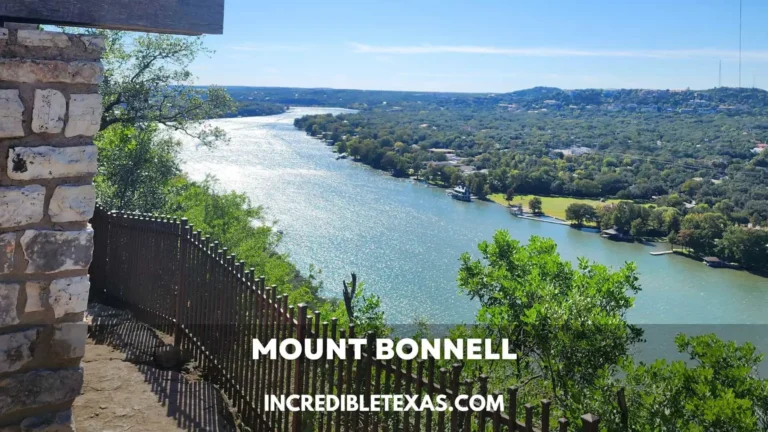
| Mount Bonnell | Short overlook with a classic hill-country view | Use it when you want a quick scenic stop after trail time |
| a weekend in Austin | Builds the Greenbelt into a fuller city trip | Use it when you want the trail to anchor a broader itinerary |
Lady Bird Lake is the closest fit when you want to stay around water but shift from creek energy to paddleboards, bridges, and a more central Austin scene. It gives you a different kind of lake day without leaving the city core.
Mount Bonnell works when you want a short overlook after the Greenbelt instead of another long hike. The change of pace is useful if the trail gave you the outdoor portion you wanted and you now want a quick view with less effort.
A weekend in Austin is the natural next click if you want the Greenbelt to become one anchor in a larger trip. The trail fits neatly into a broader Austin plan because it gives you the outdoors without consuming the whole schedule.
If you are building a local day instead of a visitor itinerary, Zilker and Barton Springs are the easiest pairings because they stay close to the same part of town. The short driving radius keeps the day connected instead of scattered.
For a more varied Austin outing, use the Greenbelt as the active piece, then add one calm stop and one city stop. The result feels balanced without turning the day into a rushed checklist.
If you are staying in the area for lunch or sunset, Zilker, Barton Springs, and Lady Bird Lake give you three very different finishes with the same trail base. That is an easy way to make a simple hike feel like a full Austin day.
The Greenbelt is also a good reminder that Austin outdoor plans do not have to be oversized to feel complete. A short trail, one creek stop, and one nearby add-on can be enough to turn a regular afternoon into the kind of outing people remember.
You can keep it casual, make it sporty, or stretch it into a bigger itinerary without changing the basic playbook, and it is easy to repeat in different seasons. The trail stays easy to recommend because it adapts to different kinds of days.
Barton Creek Greenbelt FAQ
How long is Barton Creek Greenbelt?
The city describes more than 12 miles to explore, and the main corridor runs about 7.5 miles. You can treat that as a flexible trail system rather than one fixed route, which is why a short visit and a long hike can both make sense here.
If you only have a little time, choose one access point and stay near the creek instead of trying to cover the whole corridor.
Where do you enter Barton Creek Greenbelt?
The main access points include Zilker, Spyglass, Barton Hills School Park, Gus Fruh, 360, Gaines, and Trail’s End / Camp Craft Trail. If you want the easiest first visit, start at Zilker and work outward from there.
That approach keeps the drive simple and makes the route easier to understand the first time you go.
Can you swim in Barton Creek Greenbelt?
Yes, but the creek is conditions-based rather than pool-like. Water can rise or shift after rain, and some of the prettiest-looking spots are not the safest spots for a casual dip.
If you want a more predictable swim day, use Barton Springs Pool and keep the Greenbelt for hiking or biking.
Are dogs allowed on Barton Creek Greenbelt?
Yes, and the leash rule is simple: dogs stay on leashes 6 feet or shorter. That rule helps on narrow stretches, busy access points, and anywhere you might meet other hikers fast.
If you are bringing a dog, start early and choose a shorter route so the outing stays comfortable for everyone.
What time does Barton Creek Greenbelt close?
The city notes limited to no lighting and says park facilities close after 10 p.m. Plan your hike for daylight if you want the safest and most relaxed version of the trail.
A daytime visit gives you the best footing, the best scenery, and the fewest surprises.
If you want the simplest first trip, start at Zilker early, wear shoes with grip, and keep the rest of the plan light. That way the Greenbelt feels like a real Austin win instead of a puzzle.