From the wind-scoured mesa rims of the Chihuahuan Desert to the salty tidal marshes of the Gulf Coast, Texas holds an extraordinary collection of vanished communities. Setting out on a texas ghost towns road trip allows adventurous motorists, photographers, and history lovers to trace the boom-and-bust cycles that forged the American frontier.
Across five distinct geographic regions, explorers can inspect crumbling adobe smelters, towering company coal chimneys, hurricane-swept coastal foundations, and sunken 19th-century church walls. Mapping out your journey reveals the rich cultural diversity of immigrant miners, cattle barons, and highway pioneers who built these fleeting settlements.
Key takeaways
- Texas preserves over 500 documented ghost towns across five distinct regional corridors.
- Signature highlights include Terlingua’s mercury mines, Thurber’s 128-foot brick smokestack, Indianola’s sunken seaport, and Glenrio’s Route 66 motor courts.
- Most prominent sites offer free roadside access or affordable entry via state and county park systems.
- Respecting private property borders and adhering to the Texas Antiquities Code ensures these fragile historic landmarks endure.
Master Overview: Mapping the Vanished Frontiers of Texas
A comprehensive texas ghost towns road trip spans five distinct geographic regions, connecting Trans-Pecos mercury and silver mines, North Texas industrial coal towns, Gulf Coast hurricane ruins, Route 66 motels, and Central Texas sunken lake settlements.
During the late 19th and early 20th centuries, natural resources and transportation routes dictated the survival of Texas settlements. Towns exploded around rich cinnabar veins, high-grade coal deposits, deepwater shipping channels, and transcontinental railroad tracks.
When resource veins were exhausted, rail routes shifted, or violent hurricanes destroyed municipal infrastructure, entire populations departed. Today, these sites stand as open-air historical museums where visitors can touch original hand-hewn timbers and weathered stone foundations.
Historical surveys from the Texas State Historical Association Handbook of Texas: Terlingua document hundreds of vanished communities throughout the state. Reviewing the best ghost towns in texas shows how dramatically their environments differ across hundreds of highway miles.
The master comparison table below details the top ghost towns and abandoned settlements featured across the state:
| Landmark Settlement | Geographic Region | Historic Peak Era | Signature Preserved Ruins | Primary Road Route |
|---|---|---|---|---|
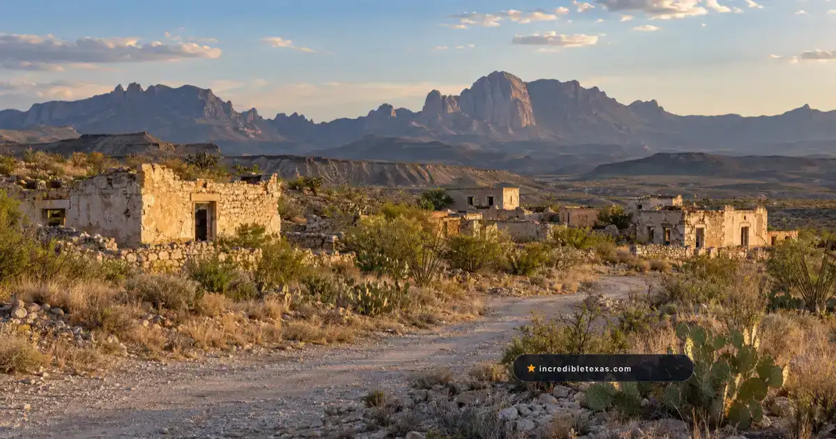
| Terlingua | Far West Texas | 1900–1942 Quicksilver | Sandstone ruins, mine shafts, Starlight | TX-118 near Big Bend |
| Shafter | Presidio County | 1880–1942 Silver | Presidio Mine, adobe church, stone walls | US-67 (Marfa to Presidio) |
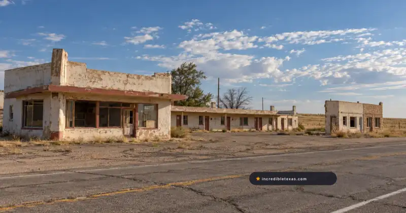
| Lobo | Culberson County | 1907–1960s Railroad | 1950s motel, gas station, desert art | US-90 south of Van Horn |
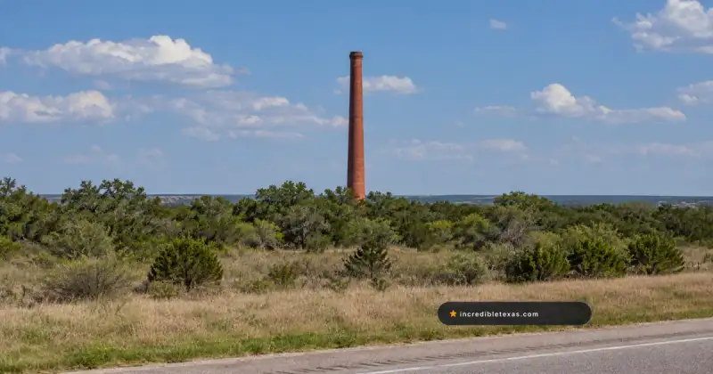
| Thurber | North Texas | 1888–1935 Coal & Brick | 128-ft smokestack, Gordon Center | I-20 west of Fort Worth |
| DFW Outposts | North Texas Metro | 1850–1890s Agrarian | Old Alton Bridge, Penn Farm barns | FM 2499 / FM 1382 |
| Indianola | Gulf Coast | 1846–1886 Seaport | Cistern ruins, cemetery, seawall | TX-316 on Matagorda Bay |
| Glenrio | Panhandle Plains | 1930s–1970s Route 66 | State Line Motel, Texaco pumps | I-40 Exit 0 (Loop 504) |
| Bluffton | Central Texas | 1852–1937 Agriculture | Church foundations, cotton gin vats | FM 2241 at Lake Buchanan |
Far West Texas: Terlingua Quicksilver and Porch Heritage
Located seven miles west of Big Bend National Park along Highway 118, Terlingua preserves 19th-century unmortared stone ruins, cinnabar mercury mine shafts, and the lively Starlight Theatre in a unique living ghost town.
Visiting the famous terlingua ghost town big bend anchor allows travelers to inspect 19th-century unmortared stone ruins, cinnabar mercury mine shafts, and the lively Starlight Theatre. Terlingua was born in the 1890s when prospectors discovered rich veins of red cinnabar ore hidden within the limestone folds of the Chisos Mountains.
Industrialist Howard E. Perry organized the Chisos Mining Company, turning the barren desert scrub into an industrial powerhouse that produced over 40 percent of the nation’s mercury. When the rich veins were depleted during World War II, the company declared bankruptcy and abandoned the works.
Regional conservation programs supported by the Texas Parks and Wildlife Department Big Bend Ranch State Park help protect surrounding desert habitats, while independent residents continue to preserve historic adobe buildings.
Today, the town functions as an active community where historic ruin preservation coexists with open-air acoustic music and dark-sky stargazing. For complete details on historic cemetery etiquette, mine shaft viewing, and dining on the famous Starlight porch, consult our comprehensive Terlingua Ghost Town visitor guide.
Presidio County: The Historic Silver Mines of Shafter
Resting along US-67 in the Chinati Mountains between Marfa and Presidio, Shafter features the historic Presidio Mine, stone processing foundations, and 1880s Catholic chapels that once yielded over thirty million ounces of silver.
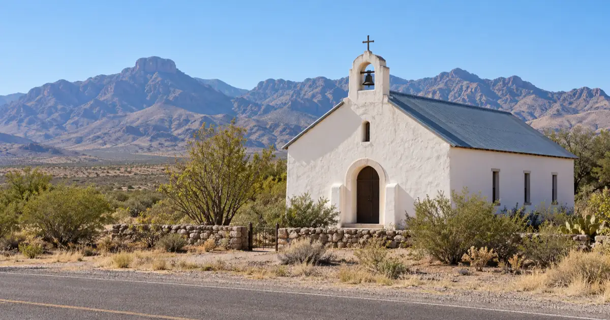
Exploring the historic shafter silver mine presidio complex along US-67 in the Chinati Mountains reveals stone processing foundations and 1880s Catholic chapels that once yielded over thirty million ounces of silver. Shafter originated in 1880 when John Spencer discovered silver float ore while riding through Cibolo Creek. Captain William R. Shafter established a major mining syndicate that dug over 100 miles of underground shafts beneath the jagged volcanic peaks.
At its peak, Shafter was a boisterous frontier enclave with over 4,000 miners, stonemasons, and smelting technicians. The Presidio Mining Company extracted silver continuously for six decades, shipping heavy bullion bars by armed wagon train to railroad spurs in Marfa.
Rising mining costs, declining silver market values, and groundwater seepage in the deep lower levels forced the mine to close in 1942. Most families vacated their stone and adobe homes, leaving behind quiet gravel streets lined with century-old limestone walls.
Motorists driving scenic US-67 can pull off to photograph the historic Church of the Sacred Heart and hillside ruins. Travelers wanting detailed mining history and photography advice can explore our Shafter ghost town silver mine guide.
Culberson County: The Desert Art Revival of Lobo
Situated on US-90 south of Van Horn, Lobo preserves an abandoned Southern Pacific railroad watering stop with a vintage motel and gas station transformed since 2001 into a private desert arts retreat.
The restored lobo desert art retreat in Culberson County sits on US-90 south of Van Horn, preserving an abandoned Southern Pacific railroad watering stop. Lobo grew around a crucial desert water well drilled by the Southern Pacific Railroad in 1907 to service steam locomotives crossing the dry Trans-Pecos flats. By the mid-20th century, deep irrigation wells sparked a short-lived cotton boom that supported a general mercantile store, diner, and motel.
When the local water aquifer became severely depleted in the 1960s, commercial farming collapsed and highway traffic shifted north to Interstate 10. By 1991, the final resident departed, leaving Lobo completely deserted.
In 2001, a small collective of European and American artists purchased the entire townsite, rehabilitating weathered stucco structures into functional artist studios and sculpture installations. The site balances historical preservation with contemporary cultural expression.
Travelers admiring the mid-century roadside signs and mountain backdrops can review our detailed Lobo Texas desert retreat guide for private property boundary rules and roadside viewing guidelines.
North Texas Industrial Heritage: Thurber’s Coal and Brick Fiefdom
Located 75 miles west of Fort Worth on Interstate 20, Thurber preserves a former company-owned coal boomtown of 10,000 residents anchored by an iconic 128-foot brick smokestack, Tarleton State University’s Gordon Center, and New York Hill.
Photographers exploring the thurber coal town ruins along Interstate 20 will find a former company-owned industrial city of 10,000 residents anchored by an iconic 128-foot brick smokestack. Unlike agricultural homesteads, Thurber was a closed corporate city owned exclusively by the Texas and Pacific Coal Company from 1888 to the 1930s. Company management operated every grocery counter, boarding house, saloon, and medical clinic, issuing company scrip instead of federal currency.
Miners from over eighteen European countries immigrated here to work deep shafts, while local kilns produced durable vitrified paving bricks that paved streets across Texas. In 1903, the town made labor history by becoming the first completely unionized closed-shop industrial town in the South.
Following the discovery of major oil fields in nearby Ranger in 1917, Texas locomotives switched from coal to fuel oil. The coal mines closed, and the company systematically dismantled housing and infrastructure during the 1930s.
Today, drivers along Interstate 20 can view the towering red brick chimney, visit the restored St. Barbara Church on New York Hill, and tour museum exhibits. For driving directions and dining options, review our dedicated Thurber Texas ghost town guide.
Dallas-Fort Worth Perimeter: Day Trips to Frontier Outposts
Within a 90-minute radius of the Dallas-Fort Worth metroplex, travelers can visit Old Alton’s historic iron truss bridge, Penn Farm’s hand-hewn cedar barns, Bluff Dale’s wire suspension bridge, and Spanish Fort’s Red River ruins.
While urban sprawl covers much of the metro area, fascinating remnants of 19th-century frontier life remain preserved in county parks and quiet rural counties. Many of these sites sit along peaceful creeks where early pioneer courthouses and stagecoach crossings once flourished.
At Old Alton in Denton County, visitors can walk across the 1884 King Iron Pratt through-truss bridge over Hickory Creek where the first county seat stood before moving to Denton. At Cedar Hill, the 1859 Penn Farm complex features primitive red cedar barns and hand-dug cisterns built before the Civil War.
Further west in Erath and Montague counties, historic river crossings like Bluff Dale’s 1890 Paluxy wire suspension bridge and the Spanish Fort frontier cattle trading hub provide quiet detours.
Travelers planning short excursions from Dallas or Fort Worth can find turn-by-turn routes and admission details in our comprehensive ghost towns near Dallas-Fort Worth guide.
Gulf Coast Hurricane Archaeology: The Sunken Streets of Indianola
Situated along Matagorda Bay in Calhoun County, Indianola preserves the submerged foundations, cistern ruins, and seaside cemetery of a major 19th-century immigrant port destroyed by catastrophic hurricanes in 1875 and 1886.
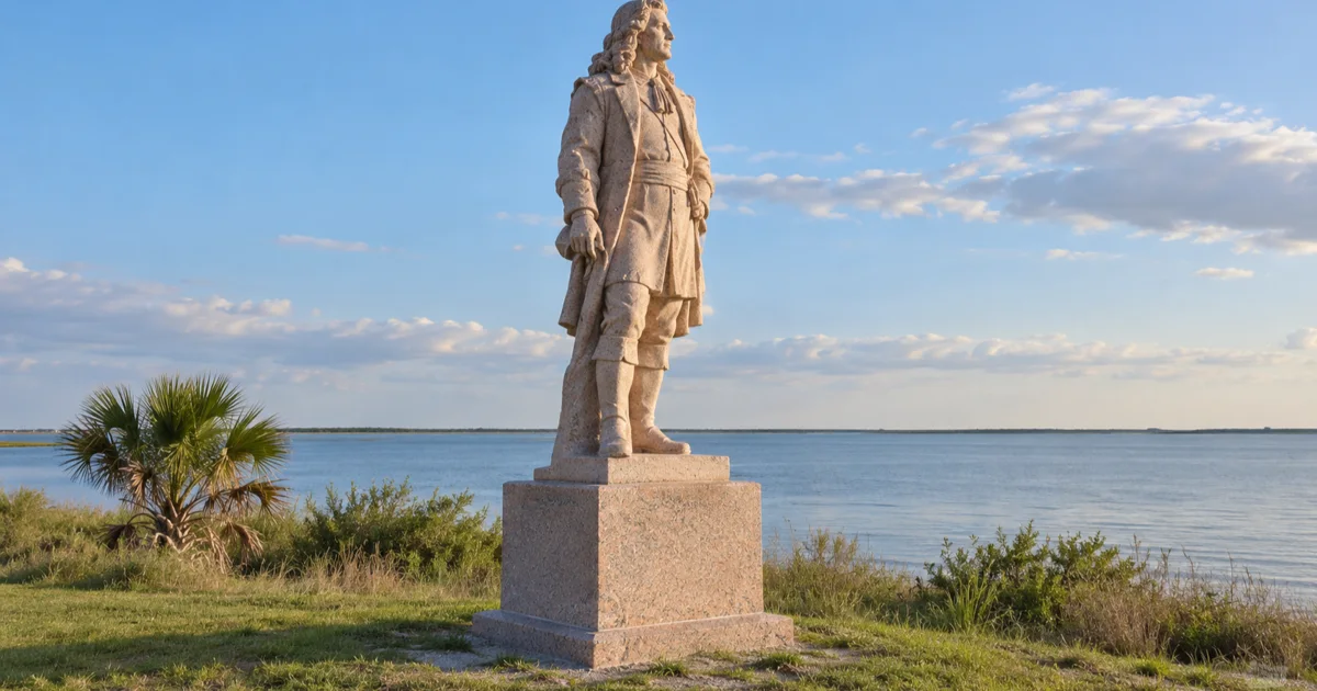
Walking among the indianola sunken ruins matagorda bay tides continually wash reveals the submerged foundations, cistern ruins, and seaside cemetery of a major 19th-century immigrant port. Founded in 1846 by Prince Carl of Solms-Braunfels, Indianola served as the primary deepwater port of entry for tens of thousands of German, Polish, and Czech immigrants arriving in Texas. Massive wharves extended into the bay, handling naval gunboats, freight wagons, and international cargo.
At its peak, the seaport rivaled Galveston in commercial importance, boasting banks, hotels, and the Calhoun County Courthouse. However, its low, exposed location on a barrier sandspit left the community defenseless against tropical cyclones.
A devastating hurricane in September 1875 destroyed substantial portions of the harbor, killing hundreds of residents. Eleven years later, an even stronger hurricane struck in August 1886, igniting fires that burned the remaining buildings and causing the county seat to move inland to Port Lavaca.
Today, travelers driving Highway 316 can walk among wave-washed shellcrete foundations, photograph the bronze statue of René-Robert Cavelier de La Salle, and tour the historic cemetery. For tide timing and park details, explore our Indianola Texas ghost town guide.
Panhandle High Plains & The Mother Road: Glenrio and Route 66 Ruins
Spanning 178 miles along Interstate 40, the Texas Panhandle preserves iconic bypassed Route 66 landmarks including the Glenrio Historic District, Jericho Gap ruins, Conway Bug Ranch, and Alanreed’s 1930 service station.
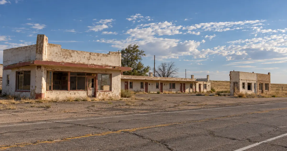
Positioned right on the glenrio route 66 border line between Texas and New Mexico, the district preserves iconic bypassed roadside architecture. During the mid-20th century, the Mother Road carried millions of cross-country travelers across the Texas high plains. Roadside entrepreneurs built distinctive Art Deco diners, neon-lit motor courts, and full-service garages to cater to migrating families.
Detailed surveys from the National Park Service Glenrio Historic District Archive confirm that seventeen intact historic buildings remain along State Loop 504. When Interstate 40 was completed in the 1960s and 1970s, older bypass routes were cut off from steady traffic, preserving intact 1950s roadside architecture.
Further east in Donley County, the historic Jericho Gap preserves the memory of unpaved gumbo mud roads that stranded Model T motorists in the 1920s. In Conway, roadside folk art thrives at the Bug Ranch, where five vintage Volkswagen Beetles stand nose-down in the prairie soil.
Automotive enthusiasts can find exit numbers, photography tips, and historical background in our complete Texas Panhandle Route 66 ghost towns guide.
Central Texas Hill Country: The Sunken Settlement of Bluffton
Submerged beneath 20 to 30 feet of water in Lake Buchanan, Old Bluffton was an 1850s agricultural community whose limestone church foundations, cotton gin vats, and cemetery plots emerge only during severe multi-year drought cycles.
Tracing the bluffton sunken lake buchanan settlement reveals an 1850s agricultural community whose limestone church foundations, cotton gin vats, and cemetery plots emerge only during severe multi-year drought cycles. Settled in 1852 along the Colorado River in Llano County, Old Bluffton was celebrated for fertile peach orchards, pecan groves, and community cotton gins. The community prospered with churches, schoolhouses, and a two-story hotel serving stagecoach travelers.
In 1937, the Lower Colorado River Authority completed Buchanan Dam to generate hydroelectric power and mitigate catastrophic downstream flooding. The resulting reservoir submerged the townsite, forcing families to dismantle timber homes and establish New Bluffton five miles west.
During historic drought cycles when Lake Buchanan falls more than 25 feet below conservation pool, the original townsite re-emerges from the lakebed. Visitors walking the dried mud peninsula can inspect 1890s church foundations and rusted cotton gin machinery.
Historical background, lake level tracking links, and antiquities rules can be found in our dedicated Bluffton sunken ghost town guide.
Curated Road Trip Itineraries: Weekend Loops and Statewide Expeditions
Travelers can choose from three targeted driving itineraries: a 3-day West Texas Desert Loop (Terlingua, Shafter, Lobo), a 2-day Panhandle Route 66 Trail (Conway to Glenrio), or a 7-day Statewide Grand Expedition covering all major boomtown regions.
Selecting the right texas ghost town itinerary depends on your available travel days, starting departure city, and geographic interests. Because Texas encompasses vast highway distances, concentrating on a specific regional corridor guarantees an immersive experience.
Here are three tested road trip itineraries designed for different travel styles:
- The 3-Day West Texas Desert Loop: Begin in Alpine, driving south along Highway 118 to spend a full day exploring Terlingua’s quicksilver ruins and cemetery. On Day Two, travel along the scenic River Road (FM 170) through Big Bend Ranch State Park to Shafter’s silver mine ruins. On Day Three, head north on US-67 through Marfa to photograph Lobo’s high-desert railroad art retreat.
- The 2-Day Panhandle Route 66 Trail: Start in Shamrock at the Art Deco U-Drop Inn, driving west along Interstate 40 frontage segments. Stop at Alanreed to view the 1930 Bradley Station and explore the Jericho Gap ruins. Continue past the Conway Bug Ranch toward Amarillo. On Day Two, drive west through Vega to spend the afternoon photographing Glenrio’s mid-century motels on the state line.
- The 7-Day Statewide Grand Expedition: For the ultimate frontier journey, begin at Indianola on Matagorda Bay. Drive northwest through Central Texas to explore Lake Buchanan and Bluffton before heading to Thurber along Interstate 20. Continue west across the Pecos River to explore Lobo, Shafter, and Terlingua before concluding in the Trans-Pecos desert.
Each itinerary connects preserved historical ruins with authentic regional dining, scenic state parks, and comfortable overnight accommodations.
Essential Road Trip Field Logistics: Vehicle Prep, Climate Realities, and Preservation Ethics
Preparing for a Texas ghost town expedition requires carrying drinking water and emergency fuel, saving offline digital maps, respecting private ranch boundaries, and strictly obeying the Texas Antiquities Code protecting historical artifacts.
Exploring abandoned towns in texas is vastly different from touring suburban museums. Many sites sit in remote desert basins or quiet coastal pastures where cellular reception drops and commercial services sit hours away.
Before departing, ensure your vehicle is in proper mechanical condition. Check tire pressures including the spare tire, inspect coolant levels, and carry at least two gallons of fresh drinking water per passenger. In desert areas like Brewster and Presidio counties, gas stations can be spaced 60 to 80 miles apart, so refill your tank whenever it drops below half full.
Weather extremes in Texas demand careful seasonal scheduling. Midsummer temperatures frequently exceed 100 degrees Fahrenheit in the Trans-Pecos desert and high plains, making outdoor exploration dangerous during midday hours. Planning excursions for spring or autumn guarantees comfortable walking temperatures and optimal lighting for architectural photography.
Most importantly, travelers must respect historical preservation ethics. Abandoned structures are fragile and often border private working ranches. Never cross locked fence lines, remove vintage building materials, or disturb historic burial grounds. Under the Texas Antiquities Code, removing cultural relics from public lands carries severe legal penalties.
By practicing responsible exploration, visitors ensure that these vanishing frontier landmarks remain preserved for future generations of American road trippers.
Frequently Asked Questions About Texas Ghost Towns Road Trips
What is the most famous ghost town in Texas?
Terlingua Ghost Town in Brewster County is widely considered the most famous in Texas, celebrated for its 19th-century quicksilver mining ruins, legendary desert porch culture, and proximity to Big Bend National Park.
How many ghost towns are in Texas?
Historical records from the Texas State Historical Association document over 500 ghost towns and vanished settlements across the state, ranging from abandoned coal company fiefdoms to hurricane-erased Gulf ports.
Is it legal to visit Texas ghost towns?
Yes, visiting ghost towns located in public parks, county right-of-way zones, and historic highway easements is completely legal. Travelers must respect posted private property boundaries and obey the Texas Antiquities Code banning artifact removal.
What is the best vehicle for a Texas ghost town road trip?
A standard passenger car or crossover vehicle handles paved highway corridors connecting major sites like Thurber, Glenrio, and Terlingua. High-clearance all-wheel-drive vehicles are recommended for remote desert gravel tracks in Presidio and Brewster counties.
What is the best season for a Texas ghost town road trip?
Autumn (October through November) and early spring (March through April) provide optimal road trip weather across Texas, avoiding extreme summer desert heat and unpredictable winter freeze cycles.