Hidden beneath the rolling blue waters of Central Texas lies one of the state’s most intriguing historical enigmas. Researching the bluffton texas sunken ghost town reveals a forgotten 19th-century agricultural community that vanished beneath Lake Buchanan during the Great Depression.
Today, this lake buchanan sunken ghost town captures national fascination whenever prolonged dry spells cause lake levels to drop. As a famous underwater town texas historians study, century-old limestone walls, rusted machinery, and gravestones emerge into daylight like an archaeological time capsule.
Note
Part of our comprehensive Texas Ghost Towns Road Trip Guide. Explore our complete statewide frontier itinerary, boomtown histories, and regional itineraries.
Key takeaways
- Old Bluffton was established in 1852 in Llano County and submerged in 1937 following the completion of Buchanan Dam.
- The ruins lie beneath 20 to 30 feet of water and only emerge when reservoir elevations drop below 995 feet above sea level.
- Notable visible structures include the 1890s Christian Church foundation, the cotton gin vat, and cemetery burial plots.
- The site is managed by the Lower Colorado River Authority, where the Texas Antiquities Code strictly bans artifact removal.
What to Expect: A 19th-Century Pioneer Settlement Beneath Lake Buchanan
Submerged beneath 20 to 30 feet of water in Lake Buchanan, Old Bluffton was an 1850s agricultural community whose limestone church foundations, cotton gin vats, hotel ruins, and historic cemetery only emerge during extreme Central Texas drought cycles.
Under normal weather conditions, boaters cruise over bluffton texas ghost town sites without realizing that a thriving pioneer village sits directly beneath their keels. The reservoir’s standard conservation pool stands at 1,020 feet above sea level, concealing over 22,000 surface acres of flooded river valley.
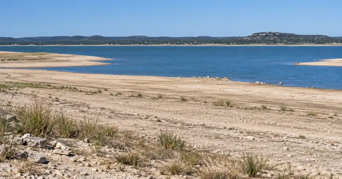
Only during catastrophic climatic periods (such as historic multi-year droughts) does the water recede enough to dry the upper lakebed. When the pool level drops below 995 feet, an exposed peninsula appears near the western shore, granting access to historic foundations.
The table below outlines the primary architectural ruins and landmark features of the submerged settlement:
| Landmark Structure | Original Construction | Historic Function | Drought Exposure Level |
|---|---|---|---|
| 1890s Christian Church | Circa 1892 | Local stone chapel and community hall | Foundation walls exposed below 995 ft |
| Old Bluffton Cemetery | 1860s–1930s | Pioneer community burial ground | Vault slabs visible below 990 ft |
| Steam Cotton Gin | Late 1880s | Processing local cotton harvest | Metal vats and concrete base visible |
| Two-Story Hotel | 1890s | Stagecoach inn and traveler lodging | Stone foundation piers visible below 985 ft |
| New Bluffton Settlement | Established 1935 | Modern relocated town on high ground | Dry upland along FM 2241 (Always open) |
The Rise of Old Bluffton: Peach Orchards, Cotton Gins, and Frontier Commerce
Settled in 1852 along the Colorado River in Llano County, Old Bluffton grew into a thriving agricultural hub famous for sweet freestone peach orchards, steam-powered cotton gins, stagecoach stops, and frontier mercantile stores.
Pioneer settler Billy Davis arrived in the fertile river bottom in the early 1850s, establishing farm tracts beneath prominent 75-foot limestone river bluffs. As other settlers moved into the region, they discovered that the sandy loam soil along the riverbanks was ideal for growing sweet freestone peaches, pecans, and upland cotton.
By the 1880s, old bluffton texas had developed into a self-sustaining commercial center. Farmers hauled wagonloads of seed cotton to the local steam-powered gin, while families gathered for Sunday services at the native limestone Christian Church.
Historical records from the Texas State Historical Association Handbook of Texas: Bluffton document that the settlement supported several general stores, a post office established in 1873, blacksmith shops, and a two-story hotel hosting travelers on the regional stage line.
Because the Colorado River regularly flooded its low banks during heavy spring storms, residents learned to build key structures on slightly elevated terraces. However, none of the early pioneers anticipated that a man-made wall of concrete downriver would eventually submerge their entire world.
The 1937 Buchanan Dam Impoundment and the Forced Relocation
In 1937, the Lower Colorado River Authority completed Buchanan Dam to generate hydroelectric power and control flooding, impounding Lake Buchanan and forcing generations of Bluffton families to sell their valley acreage and rebuild New Bluffton five miles west.
Understanding buchanan dam history 1937 requires examining how federal utility initiatives transformed Central Texas agriculture. The plan to dam the Colorado River took root in 1931 when utility tycoon Samuel Insull’s company began building Hamilton Dam. When the Insull corporate empire collapsed during the Great Depression, construction halted abruptly, leaving half-finished concrete piers standing over the water.
Under the direction of Congressman Lyndon B. Johnson and the newly established Lower Colorado River Authority, federal funding through the Public Works Administration revived the project in 1935. Renamed Buchanan Dam after state representative J.P. Buchanan, the structure stretched for more than two miles across the river basin.
The impoundment required condemning thousands of acres of private bottomland. The LCRA bought out dozens of farm families, offering cash compensation that many locals considered inadequate for fertile land held across multiple generations.
Families dismantled timber homes, salvaged barn lumber, and relocated westward to higher ground along Farm to Market Road 2241. This new community became known as New Bluffton, leaving the original stone foundations behind as the rising reservoir inundated the valley in the summer of 1937.
When the Lake Recedes: What Droughts Reveal from the Deep
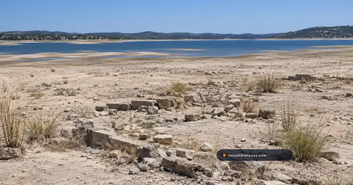
During severe drought events when Lake Buchanan fell over 25 feet below conservation pool, retreating waters temporarily exposed the stone foundation walls of the 1890s Christian Church, iron cotton gin machinery, and hotel piers.
The historic drought of 2011 was one of the most severe in recorded Texas history, dropping Lake Buchanan to an elevation of 983 feet, roughly 37 feet below full capacity. As the reservoir shrank, thousands of curious onlookers traveled to the lakebed to witness the drought reveals bluffton ruins phenomenon.
Walking out onto the cracked mud peninsula, visitors could clearly trace the original layout of the village. The stone foundations of the 1890s Christian Church stood several feet high, surrounded by scattered hand-formed bricks and fragments of antique bottle glass smoothed by decades of wave action.
Nearby, heavy iron cisterns, metal vats from the bluffton cotton gin ruins, and concrete equipment pads remained firmly anchored into the granite bedrock. Even wooden barrel staves and fencing wire emerged in remarkable states of preservation due to the low oxygen levels of deep water.
Officials from the Texas Parks and Wildlife Department Lake Buchanan Fishery Division observed that exposed structure quickly became covered with native grasses. When abundant winter rains eventually return, the Colorado River refills the basin, submerging the ruins once again beneath deep water.
The Old Bluffton Cemetery: Submerged Graves and Relocated Vaults
Before the reservoir filled, LCRA contractors exhumed 289 graves from the Old Bluffton Cemetery to reinter them at New Bluffton Cemetery on high ground, leaving behind empty burial vaults, sunken stone markers, and unmarked pioneer graves.
Moving a community cemetery was an emotional and complex logistical undertaking. In 1936, workers systematically excavated marked grave sites, transferring wooden coffins and iron caskets five miles west to the newly established New Bluffton Cemetery on high ground.
However, historical records confirm that not every grave could be identified or exhumed. Early pioneer burials from the 1850s through 1870s often featured simple cedar crosses or fieldstone headstones that had rotted or washed away in prior river floods.
When severe droughts draw the lake back, the site known as bluffton cemetery lake buchanan becomes partially visible on an elevated gravel ridge. Visitors have observed heavy concrete burial vaults, empty stone crypt foundations, and several unmovable stone ledger slabs still resting in the soil.
Descendants of Bluffton families hold annual memorial gatherings at the New Bluffton Cemetery, honoring their ancestors whose final resting place remains tied to the history of the sunken river valley.
Visiting Logistics: Lake Level Monitoring, Access Routes, and Legal Rules
Viewing the site requires monitoring LCRA pool elevations below 995 feet elevation, taking FM 2241 to public lakeshore easements, wearing protective footwear on slick granite mud, and strictly adhering to the Texas Antiquities Code banning all artifact removal.
Before planning a trip, travelers must verify current water elevations through official LCRA reservoir reports. If Lake Buchanan is at normal conservation levels (above 1,010 feet), the townsite is completely underwater and inaccessible on foot.
When lake levels drop below 995 feet, the townsite can be reached by driving west from Burnet on Highway 29, turning north onto FM 2241 through New Bluffton, and continuing toward public shoreline turnouts. Visitors should park only in designated public parking areas and avoid crossing posted private ranch lands.
Because the lakebed consists of thick clay mud, slippery algae-coated granite, and jagged zebra mussel shells, visitors must wear sturdy, closed-toe boots. Carrying drinking water and sun protection is essential, as the open lakebed offers zero shade.
Travelers looking for camping facilities or watercraft rentals can consult our comprehensive Lake Buchanan camping and cabin guide for nearby lakeside parks. Exploring these sunken ruins offers an unforgettable look into the pioneer past of the Texas Hill Country.
Crucially, all submerged ruins and exposed lakebeds are protected under the Texas Antiquities Code. Using metal detectors, excavating foundation stones, or removing historic relics is a state crime carrying heavy criminal penalties.
Frequently Asked Questions About Bluffton Texas Sunken Ghost Town
Is there a sunken ghost town in Lake Buchanan?
Yes, the 19th-century agricultural town of Old Bluffton was inundated in 1937 when Buchanan Dam was completed, placing the settlement under 20 to 30 feet of water.
When can you see Old Bluffton Texas?
The ruins of Old Bluffton are only visible during severe Texas droughts when Lake Buchanan drops more than 25 feet below its normal conservation pool of 1,020 feet elevation.
Why was Bluffton Texas flooded?
Bluffton was flooded during the construction of Buchanan Dam by the Lower Colorado River Authority (LCRA) to create a massive storage reservoir for hydroelectric power, flood prevention, and municipal water supply.
Can you walk on Old Bluffton ruins?
When extreme drought exposes the lakebed, visitors can walk carefully along public lakebed areas accessible from county rights-of-way. Removing artifacts, digging, or using metal detectors is strictly prohibited under the Texas Antiquities Code.
Where is the Bluffton Cemetery located?
The active New Bluffton Cemetery sits on high ground along FM 2241 where 289 graves were moved in the 1930s. The submerged original cemetery remains on an underwater peninsula in Lake Buchanan, occasionally emerging during droughts.