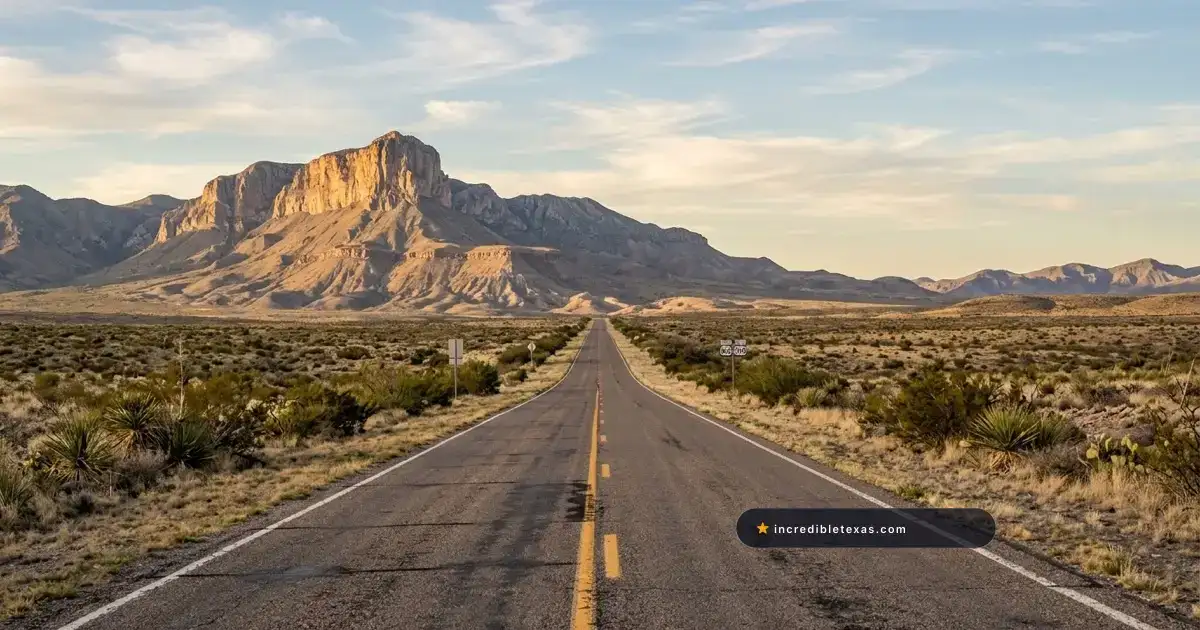
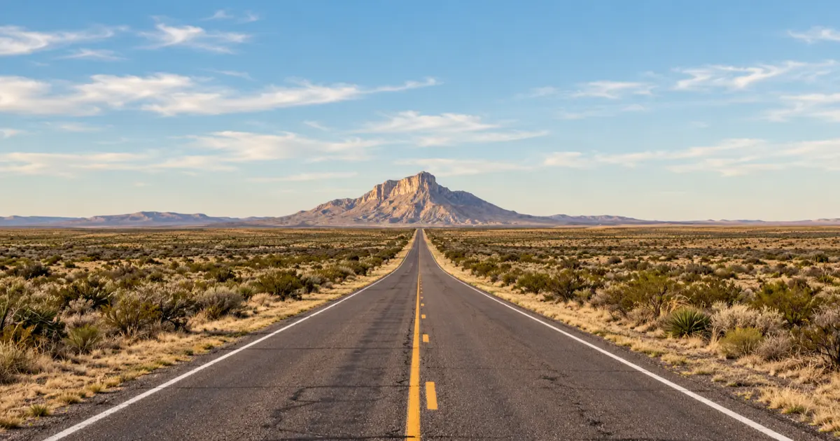
Few landscape compositions define the untamed grandeur of Far West Texas more powerfully than The Lonesome Highway. In travel photography, this iconic scene depicts a single, razor-straight ribbon of two-lane asphalt cutting through open desert scrub, drawing the viewer’s gaze across miles of emptiness directly toward the sheer limestone cliffs of El Capitan and the Guadalupe Mountains.
Capturing this famous image requires understanding the geography behind the visual myth. The composition is not a single roadside pullover, but a collection of distinct photographic viewpoints scattered across Culberson and Hudspeth counties. Mastering this shoot demands knowledge of optical compression, golden hour angles, and strict safety awareness along high-speed desert thoroughfares.
Key takeaways
- The signature Lonesome Highway shot looks north along Texas State Highway 54 toward El Capitan, 15 to 25 miles south of the US-62/180 junction.
- A telephoto lens (70-200mm or longer) is essential to optically compress the distance, making the 8,085-foot mountain dominate the frame.
- Late afternoon golden hour illuminates the southern limestone cliffs with rich amber and orange sunlight.
- Never stand or position tripods in active travel lanes; Texas highways feature 75 mph speed limits and heavy semi-truck traffic.
- No gasoline, drinking water, or cellular reception exists along Highway 54 between Van Horn and Whites City, New Mexico.
The Myth and Reality: Mapping the Lonesome Highway Corridor
In popular culture, the phrase “The Lonesome Highway” is applied loosely to several remote highways across the Trans-Pecos region. Disentangling these routes ensures photographers reach the exact coordinates that produce clean vanishing-point compositions.
Demystifying the Routes: TX-54, US-62/180, and US-285
The visual identity of The Lonesome Highway belongs primarily to Texas State Highway 54. Stretching fifty-four paved miles north from Interstate 10 in Van Horn to U.S. Highway 62/180 near Pine Springs, TX-54 bisects open desert basins with El Capitan dead center in your windshield for nearly forty continuous miles.
A secondary corridor is U.S. Highway 62/180. Approaching from the southwest past Salt Flat, this federal highway provides close-up frontal angles of the Capitan Reef escarpment as the road climbs toward Guadalupe Pass.
U.S. Highway 285, running northeast from Pecos toward Carlsbad, New Mexico, traverses the broader Delaware Basin plains. While US-285 captures the stark industrial emptiness of the Permian Basin, it sits too far east to provide the dramatic mountain-terminus perspective. Photographers heading west from the gypsum fields of Monahans Sandhills State Park typically cross US-285 before connecting to the Guadalupe approaches.
Geographic Scale and the Delaware Basin Expanse
The terrain surrounding El Capitan represents an ancient marine landscape. According to historical research by the Texas State Historical Association Handbook of Texas: Guadalupe Mountains, the peaks originated 260 million years ago as the Capitan Reef along the edge of the Delaware Sea.
Today, the Delaware Basin forms an immense, arid depression covered in creosote, yucca elata, and lechuguilla. The total lack of roadside trees, billboards, or power lines allows for uninterrupted sightlines stretching thirty to forty miles across the plain.
The sheer vertical relief of El Capitan, rising over 3,000 feet straight off the desert floor to an elevation of 8,085 feet, acts as a colossal visual anchor. The mountain dominates the horizon long before travelers reach the national park boundary.
| Highway Corridor | Key Heading | Distance to El Capitan | Visual Character | Best Photographic Feature |
|---|---|---|---|---|
| Texas Highway 54 | Northbound | 15 - 25 miles | Desert flats, straight asphalt | Classic straightaway vanishing point |
| US Highway 62/180 | Eastbound | 3 - 8 miles | Ascending mountain grade | Sheer cliff walls & road curves |
| Williams Road / Dell City | Eastbound | 12 - 18 miles | Agricultural basin, salt flats | White dunes foreground & mountain backdrop |
| US Highway 285 | Northwest | 45 - 60 miles | Delaware Basin scrub | Vast horizon lines & distant blue ridgelines |
Signature Shooting Locations: El Capitan and Guadalupe Pass
Securing the best vantage point requires planning stops according to the focal length and foreground elements you intend to emphasize. Three specific roadside sectors deliver the highest-impact imagery.
The Texas Highway 54 Vanishing-Point Approach
The most famous composition is situated along Texas Highway 54 between Milepost 30 and Milepost 45, approximately fifteen to twenty-five miles north of Van Horn. In this sector, the roadway is completely straight, cutting across low rolling swells of desert grassland.
As the road dips and rises gently, the dashed yellow centerlines form a classic leading line toward the distinctive triangular wedge of El Capitan. Wide paved shoulders and flat grassy verges provide safe locations to park vehicles well clear of passing traffic.
Setting up your camera near the edge of the paved shoulder allows you to keep the road surface in the lower third of the frame while elevating El Capitan into the upper center. Framing native soaptree yuccas along the gravel verge adds authentic West Texas texture to the foreground.
US-62/180 Roadside Pullouts and Guadalupe Pass Marker
As drivers transition onto U.S. Highway 62/180 heading east toward Pine Springs, the character of the roadway changes from long straightaways to sweeping mountain curves. TxDOT constructed several wide, paved pullouts along the westbound shoulder near the summit of Guadalupe Pass at 5,434 feet.
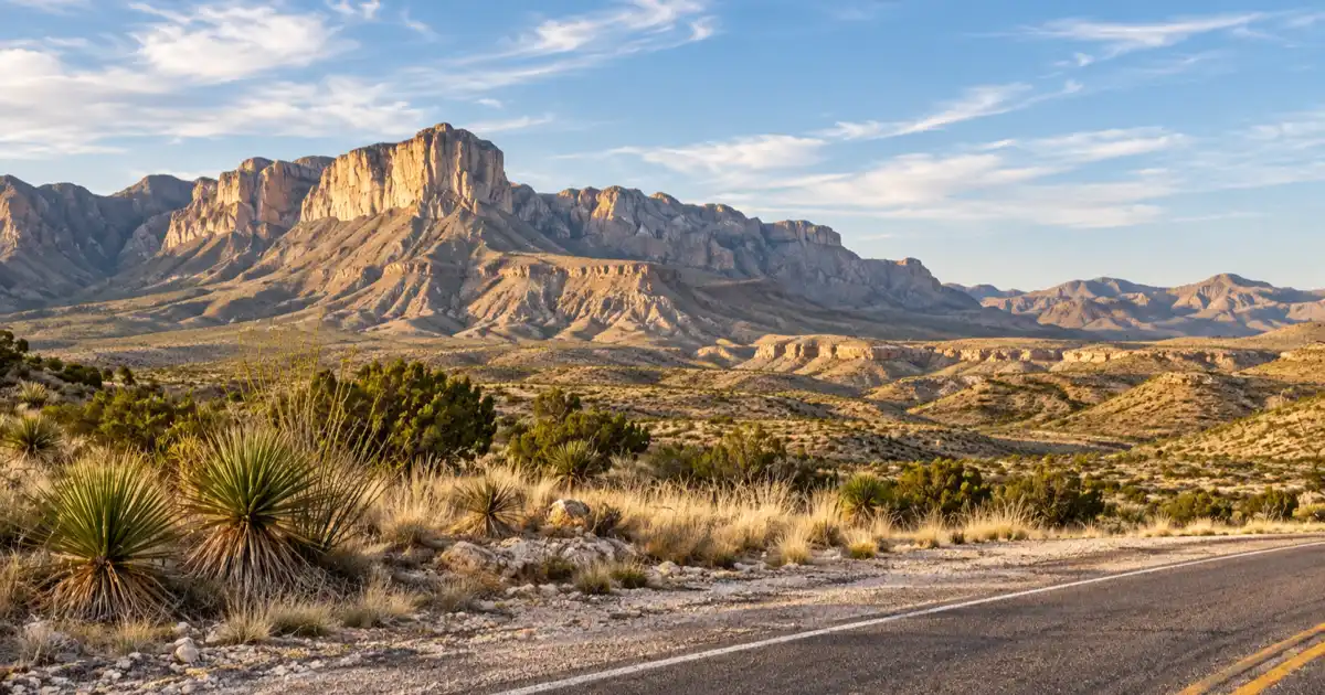
From these pullouts, photographers look directly up at the southern ramparts of El Capitan from just two miles away. The limestone cliff face reveals intricate vertical fissures, ledges, and talus aprons.
The historic Butterfield Overland Mail marker pullout provides safe parking and elevated views of the highway snaking along the base of the mountain. Hikers setting out for summit trails can review our complete Guadalupe Mountains National Park hiking guide for trailheads located just three miles beyond the pass.
Western Basin Angles: Williams Road and Salt Flat Dunes
For photographers seeking unique perspectives beyond the paved highway, Williams Road west of the national park boundary offers an exceptional unpaved alternative. Accessed via Dell City, this graded gravel route runs along the western base of the range.
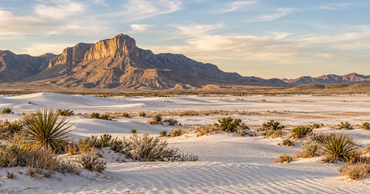
Looking east from the salt basin, the sun sets behind the photographer, illuminating the western scarp of Bartlett Peak, Shumard Peak, and El Capitan. The foreground features brilliant white gypsum dunes and salt-encrusted flats.
The stark contrast between glistening white mineral beds and dark red limestone creates dramatic monochrome or high-contrast color imagery. This location is especially effective during winter afternoons when snow dusts the high peaks.
Camera Mechanics: Telephoto Compression and Lighting Strategy
Capturing the colossal scale of El Capitan requires using optical physics to your creative advantage. Standard smartphone cameras and ultra-wide lenses often reduce the mountain to a tiny bump on the horizon.
Lens Choice and Optical Distance Compression
The secret to iconic highway landscape photography is lens compression achieved through telephoto focal lengths. Using a 70-200mm, 100-400mm, or 300mm prime lens visually compresses the physical distance between the camera, the asphalt roadway, and the mountain.
When shooting from fifteen miles away on Highway 54 at 150mm to 200mm, the distant mountain appears gargantuan, looming directly over the roadway. In contrast, wide-angle lenses (16-35mm) exaggerate foreground space, pushing the mountain far into the background.
Use a tripod mounted with a solid telephoto collar to eliminate camera shake. Set your aperture to between f/8 and f/11 to maintain crisp sharpness across both the highway markings in the middle distance and the rock texture of El Capitan. While winding routes like the Davis Mountains Scenic Loop demand wide-angle lenses for tight canyons, The Lonesome Highway is built for telephoto glass.
Golden Hour Timing and Low-Angle Western Sun
Lighting is critical when photographing the sheer limestone cliffs of the Capitan Reef. Because El Capitan faces south-southwest, morning light leaves its primary cliff face in flat shadow or heavy backlighting.
The optimal shooting window begins approximately ninety minutes before sunset. As the sun drops toward the western horizon over Dell City, warm light strikes the sheer rock face at a low angle.
The limestone transforms through a spectrum of colors, beginning with bright golden ochre, shifting to glowing amber, and finishing in deep salmon and violet. In summer, passing monsoon clouds often create dramatic god rays and localized sunbursts across the peaks.
| Lens Focal Length | Recommended Aperture | Best Subject Emphasis | Optical Effect |
|---|---|---|---|
| 70mm - 135mm | f/8.0 | Highway straightaway & entire mountain mass | Balanced road lead-in with prominent peak |
| 150mm - 200mm | f/9.0 - f/11.0 | Compressed road centerlines & El Capitan prow | Extreme telephoto compression, dramatic scale |
| 300mm - 400mm | f/8.0 | Geologic cliff details, talus slopes, rock texture | Isolates mountain summit over highway ribbon |
| 24mm - 35mm | f/11.0 | Sweeping desert foreground, yucca stalks, vast sky | Emphasizes empty desert expanse over mountain size |
Roadside Shooting Safety: Traffic, Wind, and Regulations
The open isolation of West Texas highways can create a false sense of safety. Photographers must exercise extreme vigilance when working near active travel corridors.
Seventy-Five MPH Traffic and Strict Lane Safety
Texas State Highway 54 and U.S. Highway 62/180 carry official posted speed limits of 75 miles per hour. Heavy commercial oilfield haulers, cattle trailers, and freight transports travel these routes continuously.
At 75 miles per hour, an approaching truck covers 110 feet every single second. A vehicle appearing as a distant speck over a desert rise can reach your position in less than fifteen seconds.
Never stand, sit, lie down, or position a tripod in an active travel lane. Such behavior is illegal under state transportation law and presents lethal risks. Always set up on wide gravel shoulders, behind steel guardrails, or within TxDOT paved turnouts. According to Texas Department of Transportation Rural Road Safety Guidelines, motorists must pull entirely outside travel lanes when stopping.
Guadalupe Pass Gale Winds and Tripod Stability
Guadalupe Pass is renowned among long-haul truckers and local residents as one of the windiest highway passes in the United States. High-pressure differentials funneled between the Delaware and Guadalupe mountains generate sustained winds exceeding 40 miles per hour, with gusts topping 65 to 80 miles per hour.
These gale-force crosswinds can easily blow heavy carbon-fiber tripods over, smashing expensive telephoto lenses onto the pavement. When setting up equipment along US-62/180, hang a weighted counterweight or backpack from your tripod center hook.
Keep vehicle doors firmly in your grip when exiting, as violent wind gusts can hyperextend door hinges. Photographers planning evening shoots can take advantage of the region’s Bortle Class 1 dark skies featured in our Texas dark sky parks guide, provided they prepare for sudden nighttime wind shifts.
Caution
High wind warnings are frequent along US-62/180 through Guadalupe Pass. High-profile vehicles, travel trailers, and motorhomes are frequently restricted or cautioned against crossing during active wind advisories.
Itinerary Logistics: Fuel, Supplies, and Overnight Bases
Photographing The Lonesome Highway requires advance logistical preparation due to vast travel distances and the complete absence of roadside commerce across Culberson County.
Fuel Dead Zones and Gateway Supply Towns
There are zero service stations, convenience stores, or municipal water taps along the entire 54-mile length of Texas Highway 54. From Van Horn to Whites City, New Mexico, drivers cover more than 85 miles without passing a single commercial facility.
Always top off your vehicle’s fuel tank in Van Horn before driving north on TX-54, or in Carlsbad or Dell City before heading south on US-62/180. Carrying extra drinking water and emergency non-perishable food is mandatory in this extreme desert environment.
Official travel directions and access maps are cataloged on the National Park Service Guadalupe Mountains Maps and Directions portal. In addition, download regional maps for offline navigation, as cellular phone service drops completely across most of Highway 54 and Guadalupe Pass.
Pairing with National Parks and Dark Sky Sanctuaries
The Lonesome Highway serves as an ideal photography excursion when paired with a broader Trans-Pecos road trip. Van Horn provides reliable historic motels and modern chain accommodations, serving as an ideal base for early morning shoots.
To the south, travelers can link into a comprehensive Marfa weekend itinerary to explore contemporary art foundations and historic highland plateaus. To the northeast, Carlsbad Caverns National Park lies just forty-five minutes beyond Guadalupe Mountains, offering subterranean contrasts to the vast open skies of The Lonesome Highway.
Frequently Asked Questions About the Lonesome Highway
Which exact road is The Lonesome Highway in Texas?
The classic Lonesome Highway photograph is captured looking north on Texas State Highway 54 toward El Capitan in Culberson County. Similar straight-line perspective shots are also found along U.S. Highway 62/180 approaching Guadalupe Pass from Dell City, and along remote secondary spurs connecting from US-285 across the Delaware Basin.
Is it legal to take photos in the middle of the highway?
No, standing, sitting, or setting up camera tripods in active travel lanes is illegal and exceptionally dangerous. Rural West Texas highways carry 75-mile-per-hour traffic with frequent commercial semi-trucks. Photographers must shoot from wide paved shoulders, TxDOT roadside turnouts, or field gate aprons.
What camera lens is best for photographing El Capitan from the road?
A telephoto zoom lens between 70mm and 200mm (or 100-400mm) is ideal. Telephoto focal lengths optically compress the scene, making the massive limestone cliff face of El Capitan loom dramatically large over the flat highway surface.
What is the best time of day to photograph El Capitan?
Late afternoon golden hour, roughly one to two hours before sunset, offers the best lighting. The low-angle western sun directly illuminates the sheer south-facing limestone prow of El Capitan, casting rich amber, orange, and coral hues across the rock face.
Where is the nearest gas station to El Capitan?
The nearest fuel stations are located in Whites City, New Mexico (35 miles northeast), Dell City, Texas (35 miles west), Carlsbad, New Mexico (55 miles northeast), and Van Horn, Texas (65 miles south). There are zero services inside Guadalupe Mountains National Park.
Is there cell phone service along Texas Highway 54?
Cellular signal is virtually non-existent along the 54-mile stretch of Texas Highway 54 between Van Horn and the US-62/180 junction. Smartphone mapping applications must be downloaded for offline use prior to departure.