Planning a trip for padre island national seashore primitive camping opens up an untamed coastal wilderness found nowhere else in North America. Spanning 60 continuous miles of undeveloped barrier island shoreline, South Beach offers an unmatched overlanding journey from the end of Park Road 22 to the remote Mansfield Channel.
Key takeaways
- Primitive beach camping along South Beach is completely free with standard national park entrance ($10 day pass, $25 7-day pass, or America the Beautiful pass).
- No camping permits or reservations are required for South Beach, and visitors may camp for up to 14 consecutive nights across 60 miles of undeveloped wilderness.
- Four-wheel drive with high ground clearance is mandatory south of Mile Marker 5 due to impassable sugar sand ruts and deep coquina shell banks at Big Shell Beach.
- The 60-mile beach terminates at the Mansfield Channel shipping jetties, making driving through to the resort city of South Padre Island physically impossible.
- There are zero amenities, fresh water sources, or cellular service down-island, requiring travelers to be 100% self-sufficient with extra fuel, water, and satellite SOS devices.
What to Expect on the 60-Mile South Beach Wilderness
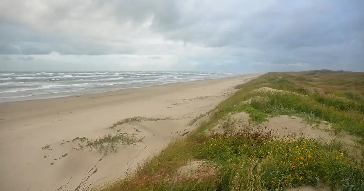
South Beach at Padre Island National Seashore protects 60 continuous miles of raw, undeveloped barrier island shoreline stretching to the Mansfield Channel. Visitors experience complete off-grid isolation, world-class surf fishing, and dynamic tidal sands without commercial developments.
Featured photo: Padre Island National Seashore beach by William L. Farr, CC BY-SA 4.0; cropped and resized.
This vast sanctuary stands in stark contrast to crowded city beaches lined with condominium towers and seawalls. Here, the landscape consists entirely of wide Gulf surf, shifting maritime sandbars, and protected inland dunes anchored by sea oats.
For a broader understanding of park amenities, visitor center exhibits, and developed loops, consult our comprehensive guide to Padre Island National Seashore. Travelers driving down South Beach leave those comforts behind for pure backcountry self-reliance.
The Longest Undeveloped Barrier Island on Earth
Padre Island stretches over 113 miles along the South Texas coastline, making it the longest barrier island in the world. The national seashore preserves the northern 66 miles of this fragile landform, shielding the hyper-saline Laguna Madre from open ocean storms.
The 60-mile stretch south of Malaquite Beach represents the most remote coastal drive in the continental United States. Once you pass through the access gates, there are no paved roads, bridges, fuel stations, or freshwater taps.
Wildlife flourishes across this isolated corridor. Ghost crabs scurry across the wet sand at twilight, coyotes patrol the dune fringes for washed-up fish, and hundreds of species of migratory raptors and shorebirds forage along the tide line.
Why South Beach Ends at the Mansfield Channel
A common misconception among first-time Texas travelers is that one can drive continuously down the barrier island to the resort hotels of South Padre Island. In reality, South Beach dead-ends abruptly at Mile 60 at the Mansfield Channel.
The Mansfield Channel is an artificial, deep-draft shipping passage dredged through the island in 1957 to connect Port Mansfield on the mainland with the open Gulf. Two massive granite rock jetties flank the cut, extending hundreds of feet into the surf.
Because no vehicular ferry or bridge crosses this channel, reaching South Padre Island requires turning around, driving 60 miles back to Corpus Christi, and traveling south via mainland highways.
| Coastal Beach Corridor | Mile Marker Span | Dominant Terrain | Recommended Vehicle Setup |
|---|---|---|---|
| North South Beach | Mile 0 to Mile 5 | Hard-packed damp tidal flats | Standard 2WD or AWD suitable in dry conditions |
| Little Shell Beach | Mile 10 to Mile 20 | Fine crushed coquina shell hash | High-clearance 4WD recommended; aired-down tires |
| Big Shell Beach | Mile 25 to Mile 50 | Heavy, loose clam shells & sugar sand | High-clearance 4x4 mandatory; 15 PSI tire pressure |
| The SS Nicaragua Corridor | Mile 50 to Mile 55 | Shifting beach cuts & high wrack lines | Dedicated 4WD with full recovery equipment |
| Mansfield Channel Terminus | Mile 58 to Mile 60 | Sandy flats bordering granite rock jetties | High-clearance 4WD; watch incoming tidal wash |
Permits, Entrance Fees, and Length of Stay Rules
Unlike the developed Malaquite Campground, primitive camping along South Beach requires no separate camping permit or reservation fee. Campers need only pay standard park entrance fees, which cover up to 14 consecutive nights of beachfront camping.
Dispersed camping is managed on a strictly first-come, first-served basis. You do not need to check in with a ranger before setting up your tent or parking your camper van along the sand.
Reviewing our curated guide to the top 10 best beaches in Texas illustrates how rare free, long-term primitive beach camping is across the broader Gulf Coast.
Free Primitive Camping with Park Entrance Pass
Access to South Beach is included with your standard federal park admission. Vehicle passes are available at the entrance kiosk on Park Road 22 or via online purchase through the National Park Service Padre Island Fees portal.
- Seven-Day Vehicle Pass: $25 per vehicle (covers up to seven continuous days of park entry and primitive camping)
- Single-Day Vehicle Pass: $10 per vehicle
- Annual National Seashore Pass: $45 (valid for 12 months)
- America the Beautiful Interagency Pass: Free entry for current pass holders and vehicle passengers
While primitive camping on the open sand carries no extra charge, travelers seeking flush toilets and cold rinse showers should utilize the developed Malaquite Campground near Mile 0 for an additional nightly fee.
The 14-Day Limit and Annual Camping Caps
Under official National Park Service Padre Island Camping Guidelines, visitors may camp primitively on South Beach for a maximum of 14 consecutive nights.
Once you reach the 14-night threshold, you and your camping equipment must completely vacate the national seashore for at least 14 consecutive days before establishing another campsite.
Furthermore, dispersed camping is capped at a cumulative total of 28 calendar nights per year per visitor. These limits prevent long-term homesteading and preserve the wilderness quality of the barrier island for all travelers.
Mile-by-Mile Down-Island Driving Guide: From Pavement to Mansfield Cut
Driving down-island transitions through four distinct geographic zones from hard-packed tidal flats near Mile 0 to severe deep shell banks at Big Shell. Maintaining steady momentum and 15 PSI tire pressure is crucial to avoid catastrophic frame high-centering.
The route demands respect, mechanical preparation, and continuous situational awareness. Coastal conditions change by the hour as winds push seawater into low-lying beach cuts.
Before venturing past the pavement, review our comprehensive field manual on driving on the beach in Texas rules to master tire deflator tools, sand recovery tracks, and public highway legal statutes.
Mile 0 to 5: Pavement End to the 4WD Boundary
Your down-island journey begins at the southern terminus of Park Road 22, located just past the Malaquite Visitor Center. Here, vehicles transition directly from asphalt onto the sand of South Beach.
The initial five miles feature wide, flat, and generally firm sand packed hard by gentle daily wave wash. Two-wheel-drive sedans, minivans, and small crossover SUVs can safely travel this initial stretch when low tide conditions prevail.
At Mile Marker 5, travelers encounter a prominent painted sign warning motorists that four-wheel-drive is required beyond this point. If your vehicle lacks true four-wheel drive with low range, turn around here.
Miles 10 to 20: Navigating Little Shell Beach
Passing Mile Marker 10 brings you into Little Shell Beach. In this coastal section, ocean currents deposit millions of delicate, crushed coquina clam shell fragments along the upper slope of the sand.
The shell layer creates noticeable rolling resistance, causing tires to sink slightly and engines to work harder. Maintain steady, moderate throttle and avoid sudden, aggressive steering adjustments that can plow your front tires into shell berms.
Anglers often establish productive campsites along this stretch, targeting speckled seatrout and red drum cruising the primary shoreline gut.
Miles 25 to 50: Conquering Big Shell Beach
Big Shell Beach is widely regarded as the most demanding off-road challenge on the Texas coast. Located where opposing northern and southern Gulf longshore currents converge, this 25-mile expanse accumulates deep, loose ridges of thick quahog and cockle clam shells.
The shell banks can measure several feet deep, creating loose troughs that swallow narrow tires. Momentum is your greatest asset across Big Shell. If you stop moving in deep shell, your wheels will spin without purchase, dropping your vehicle onto its skid plates.
Air down your tires to 15 PSI before reaching this zone. Keep your transfer case locked in 4-High or 4-Low, and follow established ruts where previous vehicles have packed down the shell beds.
Miles 51 to 60: The SS Nicaragua Wreck to Mansfield Channel
South of Mile 50, the beach broadens into flatter, windswept sand plains. Near Mile Marker 51, sharp-eyed travelers can spot the rusted iron boiler and wooden structural ribs of the SS Nicaragua, an ocean-going steamship that ran aground during a severe storm in October 1912.
The wreckage rests in the shallow surf line, serving as a landmark for offshore overlanders. Inspecting the iron engine cylinder block at low tide offers a glimpse into Texas maritime history.
Continuing south past Mile 55 brings you to the tranquil flats of the Mansfield Cut. The driving corridor ends abruptly where towering granite jetty boulders block vehicle progress at Mile 60.
Essential Overlanding Prep: Fuel, Water, and Self-Sufficiency
A successful 120-mile round-trip expedition to the Mansfield Cut requires rigorous logistics. Campers must carry a minimum of one gallon of potable water per person per day, reserve gasoline cans, and satellite communication devices due to complete cellular dead zones.
Once you drive south of Mile 5, you are on your own. Park rangers patrol down-island infrequently, often only once or twice per week depending on weather and sea turtle nesting operations. Stocking groceries, fuel, and marine equipment across coastal supply stops in our 17 best beaches in Corpus Christi guide ensures your expedition is fully prepared.
Self-sufficiency is not merely a recommendation; it is an absolute requirement for wilderness survival on a desolate barrier island.
Freshwater Rations: The One Gallon Per Day Rule
There is zero fresh drinking water available anywhere down South Beach. Brackish tidal ponds behind the dunes are undrinkable and carry high bacterial loads that will foul basic outdoor filtration systems.
Plan to pack a minimum of one gallon of fresh potable water per person per day for drinking and cooking alone. In the hot summer months from May through September, increase this allocation to two gallons per person daily to account for heavy perspiration and wind dehydration.
Bring an additional five to ten gallons of utility water stored in durable water jugs for washing dishes, cleaning sandy gear, and rinsing corrosive saltwater from your hands and camp stove.
Fuel Range Calculations and Reserve Cans
Driving in soft sand and deep shell consumes fuel at roughly double the rate of highway driving. A four-wheel-drive truck that normally averages 16 miles per gallon on asphalt will frequently drop to 7 or 8 miles per gallon while pushing through Big Shell ruts.
The round trip from the last gas station on North Padre Island to the Mansfield Channel and back covers approximately 140 total miles. At sand fuel consumption rates, a single standard factory fuel tank may leave you stranded miles short of the pavement.
Always carry at least one or two certified 5-gallon metal or rotomolded plastic fuel cans mounted securely to your vehicle rack or truck bed. Fill your vehicle fuel tank completely at the last convenience store on Park Road 22 before entering the park.
Satellite Communication and Offline Navigation
Cellular signals from Verizon, AT&T, and T-Mobile vanish completely around Mile Marker 8. From that point south to the Mansfield Channel, standard mobile phones cannot make voice calls, send text messages, or access online navigation maps.
Important
Carry a two-way satellite communicator such as a Garmin inReach, ZOLEO, or ACR Bivy Stick. These devices allow you to send check-in texts to family, monitor severe weather updates, and trigger an emergency SOS to the United States Coast Guard or county sheriff if a medical crisis arises.
Download offline satellite mapping layers on apps like OnX Offroad or Gaia GPS before departing home. Mile markers down-island consist of small wooden posts set back near the dunes, which can occasionally wash away during tropical high-water events.
Campsite Setup, High Tides, and Coastal Campfires
Federal regulations mandate pitching tents within 25 feet of the primary dune base to keep driving corridors open. Campers must position their encampments well above the daily high tide wrack line to avoid saltwater inundation during nocturnal tide shifts.
Coastal winds along South Beach blow persistently from the southeast at 15 to 25 knots. Setting up a durable camp requires specialized sand stakes, windbreaks, and careful vehicle orientation. For campers seeking shorter weekend stopovers with bathhouses and grocery markets nearby, review our Port Aransas and Mustang Island beach camping guide.
Following Leave No Trace principles protects fragile beach ecosystems and ensures the park remains open to primitive camping.
Pitching Within 25 Feet of the Dunes
To prevent vehicle collisions on the beach highway, federal park rules require all tents, trailers, and camp setups to remain within 25 feet of the seaward base of the dunes. This leaves a clear two-lane driving lane along the firm tidal flat near the water.
Under no circumstances should you pitch a tent, park a vehicle, or walk on top of the coastal sand dunes. The dunes are legally protected under the Texas Dune Protection Act, and disturbing dune vegetation carries steep fines.
Position your vehicle as a physical windbreak between the prevailing southeast ocean breeze and your tent door. Use heavy-duty spiral sand stakes or anchor guy lines to buried sandbags to prevent coastal gusts from collapsing your shelter.
Avoiding Tidal Encroachment and the Wrack Line
Tides along the Texas Gulf Coast can rise unexpectedly due to distant offshore storms or strong southeast wind pushes. A campsite that appears safely dry at 3:00 PM can be completely surrounded by churning white water by midnight.
Before pitching your tent, locate the primary wrack line, marked by dried seaweed, driftwood, and seafoam debris deposited by the most recent high tide. Establish your sleeping area and vehicle parking spots well landward of this line, close to the 25-foot dune buffer.
Warning
Never camp near low-lying beach cuts or tidal washouts where the Gulf breaches into the interior flats during extreme high tides. Check tide tables and monitor weather alerts closely; rising saltwater will rapidly submerge your vehicle hubs, causing total electrical loss.
Beach Campfire Rules and Waste Disposal
Campfires are permitted directly on the open sand of South Beach, provided they are kept small, contained, and positioned away from the dry dune grass.
You must bring your own firewood. Gathering driftwood, cutting sea oats, or burning pallets with nails is strictly prohibited inside the national seashore. Extinguish all campfires completely with seawater before going to sleep or departing camp; never bury hot coals in dry sand, as they retain severe heat that can burn barefoot beachgoers hours later.
Pack out all trash. There are zero garbage receptacles along the 60-mile beach. Bring heavy contractor trash bags and secure them inside your vehicle to prevent coyotes and raccoons from tearing open waste containers during the night.
Fishing the Mansfield Channel and Down-Island Highlights
The southern terminus at Mansfield Channel features massive granite rock jetties jutting into the Gulf, offering productive surf and jetty angling for red drum, speckled trout, and Spanish mackerel. Beachcombers also discover historical artifacts and ancient coquina shells.
Reaching the end of the 60-mile drive rewards anglers and explorers with true wilderness solitude. Standing on the granite blocks of the East Cut jetty, you can watch dolphins feed in the channel while pelicans dive into bait balls.
For travelers who prefer civilized dining and resort accommodations over backcountry overlanding, our guide to the best things to do in South Padre Island explores the lively commercial destination located across the channel.
Surf Fishing the Gulf Gut and East Cut Jetties
The waters surrounding the Mansfield Channel jetties are legendary among Texas saltwater anglers. Deep tidal currents sweep nutrient-rich water between the Laguna Madre and the Gulf, drawing schools of predatory game fish into casting range.
Anglers casting heavy spoons, live finger mullet, or cut menhaden from the jetty rocks regularly land bull redfish, black drum, king mackerel, and jack crevalle. During calm summer mornings, sight-casting for speckled trout in the emerald surf gut between Mile 55 and Mile 60 yields limit catches.
A valid Texas saltwater fishing license with a saltwater endorsement stamp is required for all anglers aged 17 and older under Texas Parks and Wildlife Saltwater Fishing Regulations. Texas Game Wardens patrol the jetties by offshore boat and utility vehicles.
| Target Fish Species | Peak Season | Primary Location | Recommended Tackle & Bait |
|---|---|---|---|
| Bull Redfish | September to November | Mansfield jetties & third surf gut | 10-ft surf rod; 50-lb braid; cut mullet or blue crab |
| Speckled Seatrout | May to August | First & second surf guts along Little Shell | 7-ft medium rod; 1/4-oz jighead; soft plastics or live shrimp |
| Spanish Mackerel | June to September | Tip of East Cut granite jetty | High-speed spinning reel; silver spoons or diamond jigs |
| Black Drum | February to April | Deep channel cuts & shell troughs | Medium-heavy bottom rig; peeled dead shrimp or crab knuckles |
| Flounder | October to December | Channel edges & bayside pass flats | Light spinning tackle; mud minnows or curly-tail grub jigs |
Historic Shipwrecks and Beachcombing Shell Finds
The colliding currents that make driving Big Shell so difficult also make South Beach one of the most productive beachcombing environments in the world. Collectors discover intact lightning whelks, scotch bonnets, giant Atlantic cockles, and fossilized shark teeth.
Exploring near Mile 51 allows visitors to examine the weathered remains of the SS Nicaragua. The 1912 shipwreck serves as an artificial reef in the surf, hosting schools of small baitfish and crabs around its rusted hull frames.
Inspecting these historical ruins highlights the powerful maritime forces that continue to shape the outer barrier coastline.
Frequently Asked Questions About Padre Island Primitive Camping
Do you need a permit to camp on South Beach at Padre Island National Seashore?
No special camping permit is required for primitive camping along South Beach. Campers simply pay the standard park entrance fee at the entrance kiosk on Park Road 22.
How much does it cost to camp on South Beach at Padre Island?
Primitive camping on South Beach is free with your paid park entrance. Standard entrance passes cost $10 for a single day, $25 for a 7-day vehicle pass, or free with an America the Beautiful pass.
Can you drive a 2WD vehicle down South Beach?
Two-wheel-drive vehicles are permitted only along the first 5 miles of South Beach under dry, hard-packed tide conditions. Driving south of Mile Marker 5 strictly requires a four-wheel-drive vehicle with high ground clearance.
Can you drive all the way to South Padre Island along the beach?
No, you cannot drive through to the commercial town of South Padre Island. The 60-mile beach ends at the Mansfield Channel, an open deep-water shipping passage with no ferry or bridge.
Where is Big Shell Beach on Padre Island?
Big Shell Beach is located between Mile Marker 25 and Mile Marker 50 along South Beach. Colliding ocean currents deposit deep ridges of heavy clam shells and soft sand that challenge even capable 4WD rigs.
Are campfires allowed on South Beach at Padre Island?
Yes, small campfires are allowed directly on the open sand below the primary dunes. Campers must bring their own firewood because gathering driftwood or native vegetation inside the national seashore is strictly prohibited.
What happens if your vehicle gets stuck down-island?
The National Park Service does not perform vehicle towing or extraction services. Stranded motorists must contact specialized commercial 4WD recovery operators whose fees routinely exceed $1,200 to $3,500 down-island.
How long can you camp on South Beach at Padre Island National Seashore?
Campers may stay for up to 14 consecutive nights on South Beach. After 14 nights, you must vacate the park for at least 14 days before returning, with an annual cap of 28 total nights per calendar year.