
Studying Texas weather extremes reveals a state governed by violent atmospheric collisions, catastrophic deluge benchmarks, and record-breaking temperature swings. Navigating these regional weather shifts connects directly to the historical resilience and frontier grit explored in our guide to the heritage of Texas traditions and culture.
Key takeaways
- Texas holds an official state temperature span of 143 degrees Fahrenheit, ranging from -23°F in Tulia and Seminole to 120°F in Seymour and Monahans.
- Alvin, Texas established the all-time 24-hour U.S. rainfall record in 1979, recording 43.0 inches during Tropical Storm Claudette.
- Hurricane Harvey dropped 60.58 inches near Nederland in 2017, discharging over 33 trillion gallons of water across southeast Texas.
- Texas leads the United States with an average of 132 to 155 confirmed tornadoes annually, driven by dry line boundary collisions.
- A certified 6.4-inch hailstone weighing 1.26 pounds recorded in 2021 struck Hondo, Texas, establishing the state benchmark.
The 143-Degree Temperature Swing: From -23°F to 120°F
Texas features an official temperature extreme span of 143 degrees Fahrenheit between its all-time record low and high. Analyzing extreme weather in Texas uncovers historic shifts where sub-zero polar outbreaks freeze coastal bays, followed months later by blistering triple-digit heat waves that bake desert plains.
According to certified Texas weather records published by the Office of the Texas State Climatologist Data Portal, this 143-degree range rivals northern continental states. Without natural geographic barriers like east-west mountain ranges, polar cold pools sweep unimpeded from the Canadian Arctic across the Great Plains directly into Texas.
Conversely, intense summer high-pressure ridges trap blistering desert air across West Texas, driving ambient air temperatures to desert basin peaks. This dynamic atmospheric scale parallels the economic and geographic size analyzed in our breakdown of what Texas looks like through a sovereign lens.
| Meteorological Category | Certified Texas Record | Location | Date of Event | National Benchmark Context |
|---|---|---|---|---|
| All-Time Low Temperature | -23°F (-30.6°C) | Tulia & Seminole | Feb 12, 1899 / Feb 8, 1933 | Tied for lowest recorded in the southern plains |
| All-Time High Temperature | 120°F (48.9°C) | Seymour & Monahans | Aug 12, 1936 / Jun 28, 1994 | Tied with major Southwest desert basin records |
| 24-Hour Rainfall Record | 43.0 inches (1,092 mm) | Alvin | July 25-26, 1979 | National record for the continental United States |
| Tropical Storm Total | 60.58 inches (1,539 mm) | Nederland (Harvey) | Aug 24 - Sept 1, 2017 | All-time continental U.S. tropical cyclone record |
| Largest Certified Hailstone | 6.4 inches diameter (1.26 lbs) | Hondo | April 28, 2021 (Recorded) | Ranked among top ten largest hailstones in U.S. history |
| Average Annual Tornadoes | 132 - 155 touchdowns | Statewide | Annual Normal | Highest annual total of any state in the nation |
Coldest Temperature Recorded in Texas: The Arctic Outbreaks of Tulia and Seminole
The coldest temperature recorded in Texas plunged to -23 degrees Fahrenheit in Tulia on February 12, 1899, during the historic Great Arctic Outbreak. Decades later, on February 8, 1933, Seminole in Gaines County matched that exact -23°F benchmark during a brutal midwinter freeze.
The February 1899 freeze remains the most severe arctic outbreak in regional history. Weather stations documented temperatures falling below zero across virtually every Texas county, dropping to -8°F in Fort Worth, -10°F in Dallas, and -12°F in Grapevine.
The arctic air was so intense that large ice sheets flowed down the Mississippi River into the Gulf of Mexico, while solid ice formed along the shores of Galveston Bay. Cattle herds across West Texas froze where they stood, transforming the open range into a silent winter landscape.
Highest Recorded Temperature in Texas: The Heat Waves of Seymour and Monahans
The highest recorded temperature in Texas peaked at 120 degrees Fahrenheit, first registered at Seymour in Baylor County on August 12, 1936. That state record stood alone for nearly six decades until Monahans in Ward County matched 120°F on June 28, 1994.
The 1936 heat wave occurred during the devastating Dust Bowl era, when widespread soil erosion and prolonged drought stripped moisture from the southern plains. Without ground moisture to cool the boundary layer through evaporation, solar radiation heated the bare earth to scorching extremes.
The 1994 event at Monahans demonstrated how the sandy desert basins of West Texas amplify summer heat domes. Monahans Sandhills, known for rolling dunes, radiated extreme thermal energy that pushed regional thermometers past previous records.
Historic Texas Rainfall Records: The 43-Inch Alvin Deluge and Hurricane Harvey
Texas holds both national and regional rainfall records, highlighted by a staggering 43-inch downpour in 24 hours at Alvin during Tropical Storm Claudette in 1979. Comprehensive Texas rainfall records confirm that the Gulf Coast is uniquely vulnerable to stalled tropical systems that pump endless moisture inland.
The warm waters of the Gulf of Mexico operate as an atmospheric vapor engine, generating storms that deposit biblical volumes of water over flat coastal topography. These storms stall when weak steering currents leave them trapped between continental high-pressure ridges.
When tropical systems stall over Texas river basins, catastrophic flash flooding follows within hours. Historic deluges in the Brazos, Colorado, and San Jacinto watersheds have redefined modern civil engineering and flood control standards.
Alvin and Tropical Storm Claudette: The National 24-Hour Rainfall Benchmark
The Alvin Texas 24 hour rainfall record stands as one of the most astonishing weather statistics in modern meteorology. On July 25 and 26, 1979, Tropical Storm Claudette stalled directly over northern Brazoria County, dropping 43.0 inches of rain in a single 24-hour period.
This phenomenal total established the official 24-hour rainfall record for the entire continental United States. Water pooled so quickly across coastal prairies that entire neighborhoods were submerged under several feet of standing runoff within hours.
Meteorologists studying Claudette noted that the storm possessed a unique tropical core that continuously regenerated convective cloud bands over Alvin. The resulting rainfall rate exceeded two inches per hour for nearly twenty consecutive hours.
Hurricane Harvey: 33 Trillion Gallons and 60 Inches of Coastal Flooding
The Hurricane Harvey rainfall record shattered previous continental storm benchmarks in late August 2017. As the Category 4 hurricane made landfall near Rockport, steering currents collapsed, pinning the storm over Southeast Texas for five consecutive days.
A rain gauge near Nederland, Texas recorded a storm total of 60.58 inches, establishing the all-time tropical cyclone rainfall record for North America. Across the state, Harvey discharged an estimated 33 trillion gallons of water, enough to fill the Houston Astrodome approximately 85,000 times over.
Flooding across Harris County inundated more than 150,000 homes, turning urban freeways into navigable waterways. Harvey demonstrated the immense destruction that occurs when tropical moisture collides with dense urban infrastructure.
Tornado Alley Dominance: Why Texas Leads the Nation in Confirmed Touchdowns
Texas records more tornadoes annually than any other U.S. state, averaging between 132 and 155 touchdowns each year. Long-term Texas tornado alley statistics compiled by the National Weather Service Fort Worth Forecast Office indicate that while central states like Kansas see higher tornado density per square mile, Texas captures the top spot for total volume.
The primary engine behind this tornado frequency is the Texas dry line meteorology that develops every spring across the western plains. The dry line separates hot, dry air flowing eastward off the Mexican plateau from humid, buoyant maritime air surging northward from the Gulf.
As the dry line advances eastward during warm spring afternoons, the sudden boundary clash triggers explosive supercell thunderstorms. These rotating storms produce intense mesocyclones capable of generating destructive tornadoes with little advance notice.
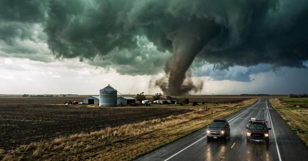
According to most tornadoes by state historical rankings, Texas accounts for roughly ten percent of all tornadoes confirmed across the United States in any given decade. Spring storm chasers from across the globe converge on highway corridors outside Lubbock, Amarillo, and Wichita Falls to document these atmospheric phenomena.
Severe Convective Hailstorms: The 6.4-Inch Record Stone in Hondo
Texas experiences some of the most destructive convective hailstorms on Earth, capped by an officially certified Texas hailstone size record set in Hondo, Texas. The Hondo Texas record hailstone recorded in April 2021 measured 6.4 inches in diameter, weighed 1.26 pounds, and spanned over 19 inches in circumference.
Hailstones of this magnitude require ferocious thunderstorm updrafts exceeding 100 miles per hour to keep heavy ice pellets suspended in sub-zero cloud layers. The stone that struck Hondo punched through residential roofs, shattered reinforced vehicle windshields, and dented structural steel beams.
Hailstorms cause billions of dollars in insured property losses across North and Central Texas each spring. To prepare residences and vehicles for severe spring squall lines, consult storm defense protocols outlined by the Texas Division of Emergency Management Preparedness Center.
Warning
Severe hailstorms across the Texas Hill Country can produce grapefruit-sized hail with terminal velocities exceeding 100 miles per hour. Motorists caught on open highways should immediately seek shelter under sturdy overpasses or commercial parking garages rather than stopping on road shoulders.
Ten Distinct Climate Zones: How Texas Geography Creates Wild Weather Contrasts
Texas encompasses ten distinct ecological and climate zones that range from arid Chihuahuan deserts and alpine mountain summits to subtropical Gulf marshes and dense piney woods. Exploring Texas climate zones diversity illustrates how 268,597 square miles of territory create microclimates that feel like separate countries.
In the northern Panhandle, the High Plains experience semi-arid continental conditions, averaging 17 inches of snow annually and frequent winter blizzards. In contrast, the Rio Grande Valley enjoys a sub-tropical climate where citrus orchards flourish and freezing temperatures occur once a decade.
Trans-Pecos desert mountains rise above 8,700 feet at Guadalupe Peak, producing alpine pine forests that collect mountain snow, as detailed in our guide to mind-blowing Texas geography facts. Meanwhile, East Texas pine forests receive over 55 inches of annual rain, supporting lush cypress bayous.
Frequently Asked Questions About Texas Weather Extremes
What is the coldest temperature ever recorded in Texas?
The coldest temperature in Texas history is -23 degrees Fahrenheit, recorded in Tulia on February 12, 1899, and tied in Seminole on February 8, 1933. Both benchmarks occurred during historic arctic outbreaks that drove polar air across the southern plains.
What is the highest temperature ever recorded in Texas?
The highest temperature officially verified in Texas is 120 degrees Fahrenheit, recorded at Seymour on August 12, 1936, and tied at Monahans on June 28, 1994. These extreme readings reflect intense high-pressure heat domes stalled over dry desert terrain.
Does Texas get more tornadoes than Kansas or Oklahoma?
Texas records more total tornadoes each year than any other U.S. state, averaging between 132 and 155 touchdowns annually. While Kansas and Oklahoma experience higher tornado density per square mile, the sheer land area and active dry line in Texas produce higher total counts.
What is the single-day rainfall record in Texas?
Alvin, Texas established the all-time 24-hour U.S. rainfall record by receiving 43.0 inches of rain during Tropical Storm Claudette on July 25 and 26, 1979. This extraordinary measurement remains the official national rainfall benchmark for a single calendar day.
Why does Texas experience such violent weather swings?
Texas experiences extreme weather shifts because cold Canadian arctic fronts collide directly with warm, moisture-laden air masses pushing northward from the Gulf of Mexico. Without east-west mountain ranges to block polar air, temperatures can plummet by 50 degrees within a few hours.
Final Travel Takeaways: How to Navigate Extreme Texas Weather
Navigating extreme weather in Texas requires situational awareness, seasonal flexibility, and consistent monitoring of official state road condition maps. Travelers setting out across Texas should consult verified road status alerts on the TxDOT Drive Texas Real-Time Highway Portal before entering remote rural corridors.
Severe weather risks shift dramatically with the seasons across the state. Spring road trippers across North and Central Texas must watch afternoon radar for tornadic supercells, while late summer coastal visitors should monitor tropical weather advisories in the Gulf.
Checking live weather advisories and packing for rapid temperature shifts allows travelers to explore the state with confidence. To plan journeys around the best seasonal windows, explore our curated travel directory featuring the best places to visit across Texas.